Aim
The module addresses methods on how Earth Observation and the use of geoinformation can support different fields of land and water management. The students will be guided to gain knowledge in selected practical examples.
Content
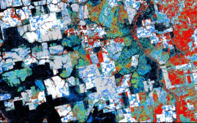
A general introduction on the subject, which strongly integrates large fields of environmental sciences and studies, is given. The students select topics in which remote sensing and geoinformation can significantly contribute parameters for answering relevant management questions. The topics include the derivation and use of parameters for monitoring land and/or water resources and examples how they can actually implemented in analytical or predictive models, or in indicator systems. The examples may include the management of the resources in rangelands, croplands, irrigation and drainage systems, river catchments, urban areas, or others. Focus may be set on special geographical settings. Depending on the selected topics and scale relevant Earth Observation parameters can include land cover and land use mapping, biophysical variables (LAI/FPAR/Chlorophyll, evapotranspiration , etc.), biomass or crop yields, soil moisture, phenological metrics and other dynamic parameters.
Coding
Software
Techniques
Content
General Course News and Updates
Internship, inno lab and MSc. idea
On Monday 17th of January at 9am we will have the following presentations: Luisa Pflumm (MSc. idea presentation): "Assess silver-backed chevrotaindistribution in Nui Chua NP (Vietnam).", supervisors: Insa Otte, Andreas Wilting (IZW) Christopher Chan (Msc. idea...
Our EAGLEs featured on the University page
Our EAGLEs Sofia, Annika, Antonio, Andreas and Nils are featured on the University webpage with their UrbanSens idea of combining mobile IoT sensors and Earth Observation data for urban climate monitoring. Their success winning the DLR Copernicus challenge rewarded...
MSc defense by Yomna Eid
Yomna will present her M.Sc. thesis "Assessment of ESA CCI+ and NASA MODIS-LST in Ecological Transects of Australia" on January 14th 2022 at 10am. From the abstract: "Identifying the best-performing MODIS LST products available for scientific analysis is instrumental...
MSc defense by Marius Witt
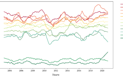
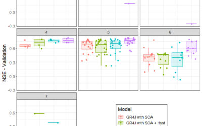
Marius Witt will present his M.Sc. thesis "Investigating discharge dynamics at catchment level usingremote sensing timeseries" on Friday 14th of January 2022 at 9am. From the abstract: The anthropogenic induced climate change is one of the foremost challenges of the...
Our students won the DLR Copernicus challenge 2021!
Great to see again our EAGLE students winning the DLR Copernicus challenge. Last year Henrik Fisser won with his truck detection approach, this year our EAGLE students Sofia Garcia, Annika Ludwig, Nils Karges, Andreas Bury and Antonio Castaneda won the DLR Copernicus...

Great dashboard by our EAGLE students
our EAGLE students created various informative remote sensing and spatial environmental data dashboards and learned a lot how to communicate their Earth Observation research in an interactive online platform. One example by our student Ronald Okoth is shown below and...
MSc defense by Christabel Ansah
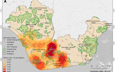
Christabel will present her M.Sc. thesis "ASSESSING THE ENVIRONMENTAL IMPACT OF OIL SPILLS IN THE NIGER DELTA, NIGERIA" on Monday 20th of December at 10am. From the abstract: "The Niger Delta region of Nigeria has been battling with an unprecedented number of oil...
M.Sc. idea presentation by Giovanni Matabishi
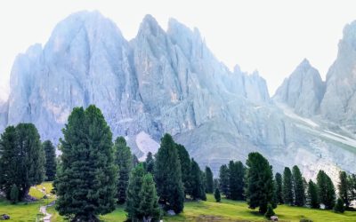
On Friday 26th of November at 10am Giovanni will present his M.Sc. idea on "Applying Artificial Light as a Focal Predictor to Model Bat Distribution in South Tyrol". His M.Sc. research is done in collaboration with EURAC research in Bolzano, South Tyrol, Italy. The...
MSc defense Diego Alarcon
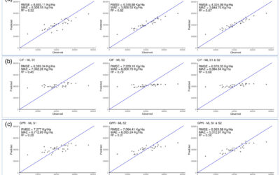
Diego will present his M.Sc. thesis "Exploring the potential of remote sensing using machine learning to predict yields for table grape farms in Chile" on Friday, 10th of December at 9am. From the abstract: Table grape is among Chile most important crops, the country...
Internship and MSc idea presentation
On Friday 12th of November at 9am the following presentations will take place: Sofia Garcia:"Production of morphology data in African and Asian cities."Internship at DLR, supervisor: Henri Debray Annika Ludwig"Analysis of alpine grassland management dynamics based on...