Aim
The module addresses methods on how Earth Observation and the use of geoinformation can support different fields of land and water management. The students will be guided to gain knowledge in selected practical examples.
Content
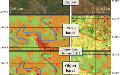
A general introduction on the subject, which strongly integrates large fields of environmental sciences and studies, is given. The students select topics in which remote sensing and geoinformation can significantly contribute parameters for answering relevant management questions. The topics include the derivation and use of parameters for monitoring land and/or water resources and examples how they can actually implemented in analytical or predictive models, or in indicator systems. The examples may include the management of the resources in rangelands, croplands, irrigation and drainage systems, river catchments, urban areas, or others. Focus may be set on special geographical settings. Depending on the selected topics and scale relevant Earth Observation parameters can include land cover and land use mapping, biophysical variables (LAI/FPAR/Chlorophyll, evapotranspiration , etc.), biomass or crop yields, soil moisture, phenological metrics and other dynamic parameters.
Coding
Software
Techniques
Content
General Course News and Updates
MSc defense Malin Fischer
Malin Fischer will present her MSc thesis "Remote sensing and machine learning for irrigation mapping in complex landscapes: a case study in Mozambique" on Wednesday, 10th of November at 9 am. From her abstract: "Analyzing the spatio-temporal distribution of irrigated...
MSc idea, inno lab and internship
On Monday, 25th of October the following remote sensing presentation by our EAGLE students will take place: 9am MSc idea presentation by Nils Karges "Exploring spatial relationships of soundscape variables in urbanareas. " (supervisors: Hannes Taubenböck and Jürgen...
MSc thesis defense by Florian Baumgartner
Floran Baumgartner will present his M.Sc. thesis "The potential of Sentinel-2 time series for yield estimation of a perennial wild plant mix-ture using machine learning" on Friday 29th of October at 10am. From the abstract: "Monocultures are generally accompanied by...
MSc idea and InnoLab presentations
On Friday 15th of October at 10am we will have the following MSc idea and inno lab presentations: Nestor Gualsaqui - M.Sc. Thesis Idea: "Pre-crop emergence weed mapping using high satellite imagery"supervisor: Dr. Michael Thiel Yomna Eid - Innovation Lab:...
MSc defense by Frederic Schwarzenbacher
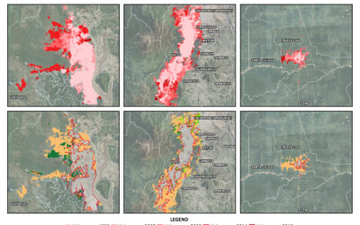
Frederic Schwarzenbacher will defend his M.Sc. thesis on Monday 6th at 3pm. The title is "Habitat suitability modeling for Desert Locust in the Awash River basin: Estimation of the breeding probability based on remote sensing, climatology and environment data" and...
MSc idea and internship presentations
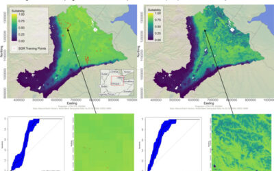
Next Monday, Sept. 20th, at 9:30am the following EAGLE students will present thier MSc. thesis idea or internship: Sofia Garcia:“Estimating socioeconomic variables in Bolivia using satellite-based NTL and electricity consumption data”(Thesis idea, supervisors Hannes...
MSc defense by Belen Villacis
Belen will defend her M.Sc. thesis “Spatio-temporal patterns of urban expansion among main biomes in Ecuador using LULC data from 1990-2018” on Wednesday 8th of September, 2pm. From the abstract: "Over the past decades, the world has experienced an accelerated...
MSc defense by Ronja Lappe
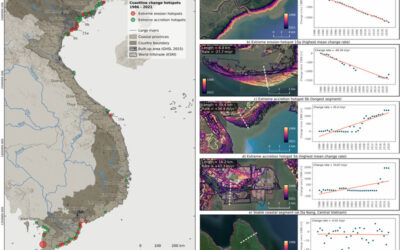
Ronja Lappe handed in her M.Sc. thesis "Assessing 30 years of coastline dynamics in Vietnam using the Landsat archive"from the abstract: "Almost half of the world’s human population lives in coastal regions, with 40 % less than ten meters above sea level. Due to...
MSc defense by Martin Koenig
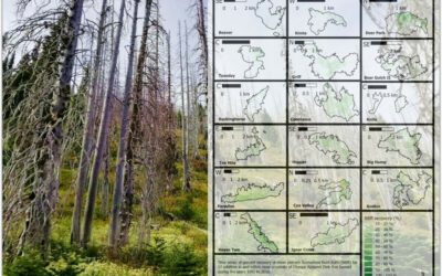
Martin König handed in his thesis with the title “Examining post-fire vegetation recovery with Landsat time series analysis in Olympic National Park (USA)”. Martin used remote sensing and ground collected data to make sense of vegetation recovery patterns for larger...
thesis idea presentations
On Monday 26th of July at 2pm we will have two MSc thesis idea presentations: Jakob Wachter (thesis idea):"Derivation of Snow cover in mountain regions from Webcam and Sentinel Imagery (thesis idea)" - supervisors Dr. Tobias Ullmann and Dr. Mattia Rossi, EURAC...