Aim
This course provides detailed knowledge of programming or coding using spatial data, especially for remote sensing and GIS tasks.
Content
Different spatial programming approaches are covered using actual remote sensing and GIS data to enable the students to apply a variety of methods in a semi-automatic manner for remote sensing data analysis. All methods will be practically applied during the course using the programming language R and maybe other programs such as GRASS, SAGA, QGIS or OTB. This course continues where the “Programming and Geostatistics” courses stopped and is considered a prerequisite. Both courses are tightly linked
Coding
Software
Techniques
Content
General Course News and Updates
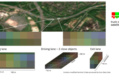
EAGLE student Henrik Fisser won ESA competition
Congratulations to Henrik Fisser, whose Sentinel-2 analysis on truck detection has been awarded the first prize for the European Data Cube COVID-19 contest! He uses the reflectance patterns of long moving vehicles in Sentinel-2 images. Please see the ESA webpage for...
MSc defense by Katrin Hasenbein
Katrin Hasenbein will defend her M.Sc. thesis on Thursday 12am on "The potential to enhance land use mapping by leveraging processing methods of time series data". from the abstract: "With the launch of the twin satellites of Sentinel-2 time series data with a high...
2020 applications
We received again a high number of very good applicants and are currently working through all application files. We will invite all eligible applicants in the next weeks for an interview. In total we received 137 eligible applications from the EU as well as North and...

MSc idea presentation by Aida Taghavi
Aida will present on Friday, May 22nd at 2:30pm her MSc idea "Potentials of Cosmic-Ray Neutron Probes for Assessing and Mapping SAR-based Soil Moisture in a Mediterranean agro-forestry ecosystem by developing an integrated ground- and space-based Modelling Framework"....
Sebastian Buchelt successfully presented his MSc thesis
Sebastian Buchelt successfully presented his MSc thesis - congratulations! Read more about his research project here.
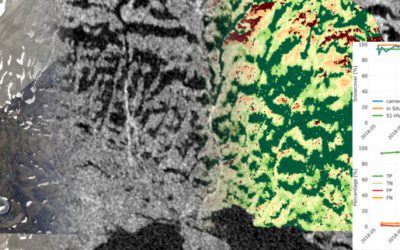
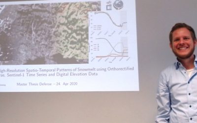
MSc defense by Sebastian Buchelt
Sebastian Buchelt will present his M.Sc. thesis "Analysis of High-Resolution Spatio-Temporal Patterns of Snowmelt using Orthorectified Photo Cameras, Sentinel-1 Time Series and Digital Elevation Data" in a virtual course room. From the abstract: " Snow is one of the...

Successful virtual MSc defense by Silvan Steiner
Congratulation to Silvan Steiner, our first EAGLE passing with a virtual MSc defense!
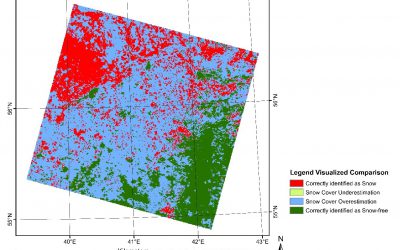
MSc defense by Silvan Steiner
On Thursday at 10am Silvan Steiner will present his M.Sc. thesis "Assessing the Potential of a Land Cover Dependent Snow Cover Detection Algorithm for the Global SnowPack". Due to the Covid19 situation his defense will be in a virtual course room. Everybody is invited...
Covid-19 situation and EAGLE
The Covid-19 situation is also challenging for the University as well as the EAGLE program. Even though we are all in the process to adapt to this new situation, the program itself is continuing as usual. All courses, exams, MSc thesis defense and so on will take...
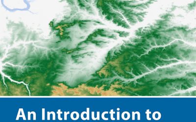
new book by our lecturer “Intro to Spatial Data Analysis”
The upcoming book by our lecturer Jakob Schwalb-Willmann, Stefan Dech and Martin Wegmann on "Introduction to Spatial Data Analysis" with QGIS and first steps in R is available for pre-order - order now and get 30% discount. This textbook aims at students and...