Lecturer
Julia Rieder
ECTS
5 ECTS
Aim
The course provides a practical introduction to LiDAR technology and point cloud analysis. Students gain hands-on experience with LiDAR data, from acquisition principles to processing and interpretation, and learn how LiDAR supports applications such as terrain modelling, forestry, and others. The course emphasizes critical understanding of data quality, limitations, and real-world use cases
Content
This course provides an overview of the scientific field surrounding LiDAR as a key technology for three-dimensional Earth observation. The course covers the fundamentals of LiDAR remote sensing, point cloud data structures, and processing methodologies across platforms ranging from spaceborne and airborne systems to terrestrial and mobile laser scanning. Furthermore, the course highlights current developments and emerging analytical possibilities enabled by advanced point cloud analysis and discusses future potential as LiDAR technologies and methodologies continue to evolve and converge with related disciplines.
Coding
Software
Techniques
Content
General Course News and Updates

🦅 Don’t Miss the EAGLE M.Sc. Application Deadline – May 15
The deadline to apply for the EAGLE M.Sc. “Applied Earth Observation and Geoanalysis of the Living Environment” program is approaching quickly - applications must be submitted before midnight May 15th (CEST) for a winter term start in October. Located at our EORC at...

EAGLE social ski retreat
To recharge their batteries after an intense semester, some EAGLE students went skiing together in the Austrian Alps, taking the opportunity to experience cold-region environments themselves. Beyond the thrill of the slopes, the trip allowed students to observe snow...

EAGLE Internship Presentation: Geomorphological Monitoring at Askja Caldera: Field Observations of Subsurface Instability
On April 28, 2026, Hanna Zoë Schulten will present her internship results on " Geomorphological Monitoring at Askja Caldera: Field Observations of Subsurface Instability" at 12:30 in seminar room 3, John-Skilton-Str. 4a. From the abstract: Volcanic calderas are...

From Data to Impact: Viktoria Veith’s Internship at WWF
Understanding the environmental consequences of conflict is one of the most pressing challenges in contemporary Earth observation. During her internship at WWF, EAGLE MSc student Viktoria Veith has been working at the intersection of remote sensing, policy, and...

EAGLE MSc Defense: Developing a Farmland Habitat Biodiversity Indicator for Bavaria (in line with OECD Guidelines)
On March 31, 2026, Suriya Elango will present his Master Thesis on " Developing a Farmland Habitat Biodiversity Indicator for Bavaria (in line with OECD Guidelines)" at 12:00 in seminar room 3, John-Skilton-Str. 4a. From the abstract: Farmland Biodiversity is...

Successful MSc Defense: Advancing Synthetic High-Resolution Remote Sensing
We are pleased to congratulate Georg Starz on the successful defense of his MSc thesis within the EAGLE programme. His work, titled “Synthetic High-Resolution Remote Sensing Image Generation – A Comparative Study of Model Training, Surface Data Variability and...

EAGLE Innolab Presentation: Very high-resolution UAV-based Weed Segmentation: Data Processing, Modelling, and Exploration of Vision-Language Models for Agriculture
On April 28, 2026, Hanna Schulten will present her Innolab results on "Very high-resolution UAV-based Weed Segmentation: Data Processing, Modelling, and Exploration of Vision-Language Models for Agriculture" at 12:00 in seminar room 3, John-Skilton-Str. 4a. From the...

EAGLE MSc Defense: Assessing the potential of multispectral UAS and PlanetScope imagery for estimating vegetation structure and biodiversity metrics in urban green spaces
On March 27, 2026, Max Merzdorf will present his Master Thesis on " Assessing the potential of multispectral UAS and PlanetScope imagery for estimating vegetation structure and biodiversity metrics in urban green spaces" at 12:30 at the meeting room 01.B03 (first...

EAGLE Students in Kruger National Park: Internship at SANParks
EAGLE MSc students Sebastian Rothaug and Clemens Schömig are currently completing an internship/InnoLab with SANParks in Kruger National Park, South Africa. During their stay, they are contributing to a project on fire and drought dynamics in savanna ecosystems. Their...
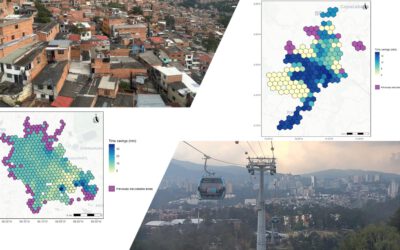
EAGLE MSc Defense: Assessing the accessibility improvements, public perception and potential beneficiaries of cable car systems in Mexico City and Medellin
On March 26, 2026 Angie Torres Lopez will present her Master Thesis on " Assessing the accessibility improvements, public perception and potential beneficiaries of cable car systems in Mexico City and Medellin" at 14:00 in seminar room 3, John-Skilton-Str. 4a. From...