Aim
In this course we will learn the alternative image analysis paradigm of object-based image classification. Image objects are areas in images which consist of pixels from the same land-cover class (e.g. buildings, water surfaces, vegetation) and allow the application of additional image classification methods in comparison to pure pixel-based methods and the integration of multi-modal date (e.g. vector data).
Content
In the course we will use satellite images and high resolution aerial images in combination with vector data and analyze various image classification methods (nearest neighbor -> random forests -> deep learning) to extract relevant information from the images.
We will use the software “eCognition”.
The course will be held on 3 days in Würzburg plus an introductory lecture which is being held online.
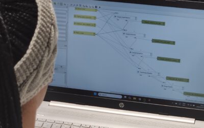
Session 1: getting to know to image objects and eConition software, basic classification methods
Session 2: advanced classification (Machine Learning)
Session 3: Deep Learning
Coding
Software
Techniques
Content
General Course News and Updates
EAGLE Internship Presentation “Glacier Surface Dynamics and Snowline Analysis Using Remote Sensing Data”
On January 21, 2025, Daria Ushakova will present her internship on "Glacier Surface Dynamics and Snowline Analysis Using Remote Sensing Data" at 13:00 in seminar room 3, John-Skilton-Str. 4a. From the abstract: This internship focused on analysing glacier surface...
EAGLE Master Thesis Defense “Linking Wildlife Conservation to Nature’s Contributions to People: A Case Study for the European Wildcat (Felis silvestris silvestris) in German Protected Forests”
On January 21, 2025, Svenja Dobelmann will defend her master thesis" Linking Wildlife Conservation to Nature’s Contributions to People: A Case Study for the European Wildcat (Felis silvestris silvestris) in German Protected Forests" at 12:00 in seminar room 3,...
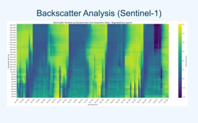
EAGLE Daria did her internship in Bergen
Our EAGLE student Daria recently wrapped up an internship at the University of Bergen in the Remote Sensing research group. With the support of her supervisor, Dr. Benjamin Abreu Robson, she got to work on the Jostedalsbreen glacier using drone and satellite data. Her...
EAGLE alumnus Henrik Fisser presenting polar research
Our EAGLE alumnus Henrik Fisser recently visited us after a research stay in the United States. He is now pursuing his PhD at UiT The Arctic University of Norway, specifically in the Earth Observation Department. UiT is renowned for its cutting-edge research in Earth...
Orfeo Toolbox covered in our courses
As part of our international EAGLE MSc courses, we include comprehensive training on the powerful Orfeo Toolbox (OTB) software. OTB is an open-source library for processing remote sensing imagery, offering advanced algorithms for tasks such as image segmentation,...
EAGLE Internship Presentation ” Research and development of data strategies for disaster management, early warning systems, and refugee data analysis”
On January 07, 2025, Sarah Schneider will present her internship " Research and development of data strategies for disaster management, early warning systems, and refugee data analysis" at 14:00 in seminar room 3, John-Skilton-Str. 4a. From the abstract: The...
Master Thesis Presentation “Animal Path Segmentation and Analysis via Deep Neural Network Regression”
On January 14, 2025, Konstantin Müller will defend his master thesis " Animal Path Segmentation and Analysis via Deep Neural Network Regression " at 12:00 in seminar room 3, John-Skilton-Str. 4a. From the abstract: Animals play a vital role for well-functioning...
Internship network fair
Today, we provided our international Eagle MSc students with access to the professional network of our EORC to assist them in finding suitable internships or MSc thesis topics. Several individuals offered their networks, including Hannes Taubenboeck for georisk and...
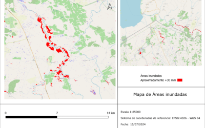
Internship Presentation: Application of synthetic aperture radar (SAR) data: Case study in flood mapping in Costa Rica and technical capacity building of the PRIAS team
On December 17, 2024, Ariana Sofía Argüello Cordero will present her internship " Application of synthetic aperture radar (SAR) data: Case study in flood mapping in Costa Rica and technical capacity building of the PRIAS team" at 12:00 in seminar room 3,...
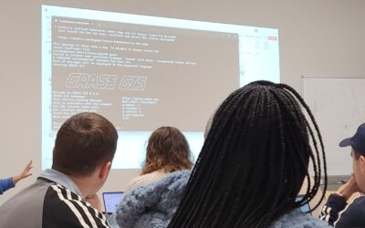
GRASS software for Earth Observation
In our international EAGLE MSc program, we go beyond the limitations of a single programming language or software environment. Our goal is to empower students to leverage a wide range of scientific tools effectively. They gain insight into the strengths and...