Aim
Designing scientific graphics that provide all necessary information without being too packed, focusing on the essential message and being able to actually create such graphics will be covered In this class. All necessary tools and and approaches to create adequate figures and maps will be covered.
Content
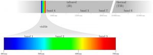
figure from the book “Remote Sensing and GIS for Ecologists” by Wegmann, Leutner and Dech, created with tikz
General guidelines of scientific graphics and maps will be covered based on e.g. Tufte and followed by practical implementation of graphic ideas, as well as critical evaluation of the results. Only open source program will be used such as R or tikz/pgf and students will have the opportunity to work specifically on certain scientific graphics or maps using e.g. ggplot2 and explore the potential and limits of good scientific graphs. Good map designs will be discussed as well and common mistakes will be pointed out. After this course you will be capable to create your own graphics for a specific scientific purpose e.g. your M.Sc. thesis.
Coding
Software
Techniques
Content
General Course News and Updates
Social event in the boulder gym
Last week we spend a few hours in the boulder hall to enjoy a day without courses, do some climbing and have plenty of time to chat. Many EAGLEs from the current and old generations joint us as well as many lecturer. Beside the social event we also collected Lidar...
MSc defense Caroline Busse
On Tuesday 22nd of November at 1pm we will have the MSc thesis defense by Caroline on "Change Detection using Sentinel-1 and Sentinel-2 Time Series: A Comparison of Models for the Detection of Forest Disturbances." from the abstract: "Forests provide essential...
internship, innoLab and MSc idea presentations
On Tuesday 22nd of November at 12am we will have the following presentations: Dilara Kim: „Automated glacier snowline mapping from multi-sensor satellite observation“, InnoLab, EURAC Research, Supervisor: Dr. Martina Barandun Walid Ghariani: „PM2.5 Prediction Using...
New EAGLE Earth Observation professors
We are very happy to welcome two new professors within the EAGLE M.Sc. program! Prof. Dr. Hannes Taubenböck and Prof. Dr. Tobias Ullmann will strengthen the urban remote sensing and radar earth observation within the EAGLE program. Various new courses are already...
MSc defense by Larissa Gorzawski
On Wednesday 5th of October at 2pm Larissa will present her M.Sc. thesis "Deep transfer learning on street-level imagery for classification of seismic building types in Lima, Peru". From the abstract: "Comprehensive exposure models for seismic risk assessment require...

M.Sc. defense by Jakob Rieser
On Monday, 26th of September at 10am, Jakob will present his M.Sc. thesis „A Synergistic Use of Optical and SAR Remote Sensing Data for the Long-term Evolution of Biocrusts and their Activity Across Diverse Dryland Ecosystems”. from the abstract: "Biological soil...

MSc defense by Christopher Chan
Chris will present his M.Sc. thesis "Investigating the capability of UAV imagery in AI-assisted mapping of Refugee Camps in East Africa" on Friday 16th of September at 2pm. From his abstract: " Refugee camps and informal settlements provide accommodation to some of...
MSc defense by Annika Ludwig
Annika will present her M.Sc. thesis "Analysis of alpine grassland management dynamics based on webcam and optical remote sensing time series" on Friday 9th of September at 9am. From the abstract: "The aim of this study is to detect relationships between environmental...

EAGLE summer dialogue 2022
After two years we finally had our EAGLE summer dialogue again with many Earth Observation alumni, now working in various research organizations and companies. Great to talk to all our past and present students and also seeing all the students getting to know each...
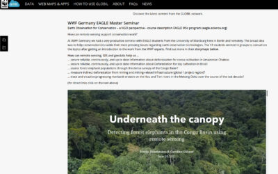
WWF course on applied Earth Observation
Our EAGLE students joint a course offered by the earth observation unit at WWF and learned how to apply remote sensing within a conservation NGO. They learned a lot and their results are published as story maps on their webpage...