On Monday, 26th of September at 10am, Jakob will present his M.Sc. thesis „A Synergistic Use of Optical and SAR Remote Sensing Data for the Long-term Evolution of Biocrusts and their Activity Across Diverse Dryland Ecosystems”.
from the abstract: “Biological soil crusts or biocrusts are thin layers of cyanobacteria, lichens, mosses, and fungi, that develop naturally on the topsoil layer under conditions unfavourable for higher plants. These are usually defined by low precipitation rates and high temperatures, making them widespread within the global arid and semi-arid drylands. In areas beyond these drylands, they are also present as in smaller quantities caused by intense human impact and frequent disturbance of the land surface. They consist of poikilohydric organisms capable of adjusting their metabolic activities depending on the water availability. Biocrusts provide various ecosystem functions influencing climate, air quality and prohibiting soil erosion. They are however highly endangered by climate change (i.e., higher temperatures and lower precipitation) and land use intensification, as their potential habitats are expected to decrease.
Remote sensing methods were used to estimate biocrust coverage and distribution as well as changes in metabolic activity due to water availability based on multispectral and hyperspectral data within the global drylands. There is a clear lack of studies focusing on biocrust occurrences outside these areas, e.g., in the temperate climates. Also, biocrusts were not yet characterized using synthetic aperture radar signals, which are sensitive to changes in structure and water content of the surface.
This study was conducted in well-researched biocrust covered areas in Germany, Spain, Israel, and South Africa, featuring different characteristics in climate, topography, geology, biocrust abundance and communities and accompanying vegetation.
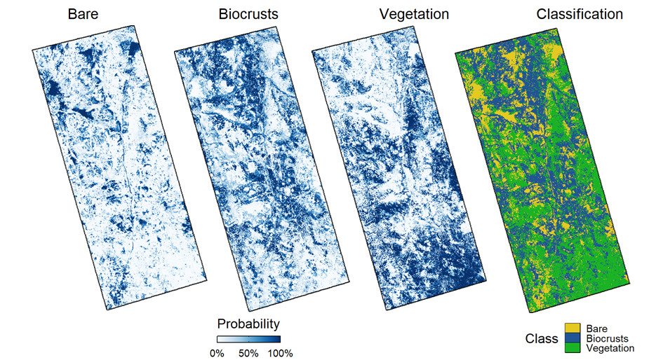
In this study, open-source space-born remote sensing data was used to derive biocrust specific multispectral indices from fused Sentinel 2 and Landsat 7&8 data and backscatter intensities for different polarizations and mathematical band combinations from Sentinel 1 SAR data. The resulting gridded time series on 10 m resolution was analysed over a full five-year period from January 2017 to December 2021. Spatiotemporal metrics were derived from these data that were used in Random Forest models of classification and regression to estimate distribution and coverage of biocrusts and other land cover types within the different study areas. To evaluate effects of topography on the distribution of land cover the distribution probabilities were spatially correlated to topographic attributes characterizing the study areas. The characteristics of biocrusts and how they differ from other land cover types in both SAR and multispectral metrics was evaluated as well as the response to water availability caused by individual rainfall events and seasonal weather changes.
With overall accuracies of above 97%, the spatial delineation proved to work successfully in all study areas. It could be observed that multispectral and SAR metrics were of different importance throughout the different study areas. Influence of topography on biocrust distribution could be detected. Significant changes of metrics could be detected for seasonal and rainfall event-based changes in biocrust activity. Hereby, the SAR metrics were able detect short-term changes in surface roughness and water content due to their high acquisition density, while the multispectral data was able to detect seasonal differences in metabolic activity, as the occurrence of cloud cover reduced the number of usable observations. The results of all study areas were compared, and differences were discussed.
This study proved the high transferability of space-born remote sensing methods for biocrust detection through areas of different scales and climatic situations. It provides essential impulses to further dive into the topic and analyse the long-term evolution of biocrusts.”
supervisors: Sarah Schoenbrodt-Stitt, Tobias Ullmann
![[spotlight] Lecturer Spotlight: Martin Wegmann](https://eagle-science.org/wp-content/uploads/2026/07/Martin_Wegmann_EAGLE_lecture_2026-400x250.jpg)


