Aim
Designing scientific graphics that provide all necessary information without being too packed, focusing on the essential message and being able to actually create such graphics will be covered In this class. All necessary tools and and approaches to create adequate figures and maps will be covered.
Content
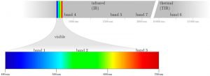
figure from the book “Remote Sensing and GIS for Ecologists” by Wegmann, Leutner and Dech, created with tikz
General guidelines of scientific graphics and maps will be covered based on e.g. Tufte and followed by practical implementation of graphic ideas, as well as critical evaluation of the results. Only open source program will be used such as R or tikz/pgf and students will have the opportunity to work specifically on certain scientific graphics or maps using e.g. ggplot2 and explore the potential and limits of good scientific graphs. Good map designs will be discussed as well and common mistakes will be pointed out. After this course you will be capable to create your own graphics for a specific scientific purpose e.g. your M.Sc. thesis.
Coding
Software
Techniques
Content
General Course News and Updates

MSc idea and internship presentations
On Friday, 8th of November, from 10-12am the following presentation will take place in room 01.009, OKW 86: Michael Wang:"Deriving Surface Heat Island Intensities for TraK and CURE" - internship and thesis idea presentation Patrick Sogno:"The Hitchhikers Guide to an...
M.Sc. idea presentations and internship presentation
On Friday 25th of October several EAGLEs will present their M.Sc. thesis ideas and report back from an internship experience. It will take place at 10am in room 1.009, OKW 86. Katrin Hasenbein (MSc idea): "The potential of time-series data to improve fine scale...

M.Sc. idea presentation by Salim Soltani
Salim Soltani will present his M.Sc. idea ""Spatio-Temporal Analysis of Urbanization caused by the Belt-and-Road Initiative" on October 23rd at 10:30 in 1.009 OKW 86.
Welcome of the 2019 EAGLEs
On Monday, 14th of October, at 4 p.m., we will again welcome a new generation of EAGLEs (Z6, 01.002). After the official welcome and some introductory presentations, we will also introduce the lecturer and provide first details about the upcoming semester(s)....
Internship and InnoLab presentations
On Monday, 14th of October, at 5pm in room ZHSG 01.002, after the welcome of the new EAGLEs we will have the following internship and Innovation Laboratory presentations: Pawel Kluter (Internship): "Remote Sensing in the Federal Criminal Police Office" Pawel Kluter...

M.Sc. presentation by Johni Miah
Johni Miah will present his M.Sc. thesis " Detecting and Assessing Ground Subsidence of Dhaka City, Bangladesh, Using Synthetic Aperture Radar Data of Sentinel-1" on September 30th at 2pm in OKW 86. From the abstract: " The identification and measurement of ground...

Several Successful M.Sc. defenses
Several of our EAGLE students successfully defended their M.Sc. thesis in the past month. We congratulate all of them and especially wish the ones who already started their own Earth Observation company all the best!
M.Sc. defense by Louis Freytag Loringhoven
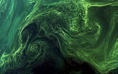
On Tuesday, 24th at 2pm Louis Freytag-Loringhoven will present his M.Sc. thesis "Remote sensing of water quality using Sentinel-2 towards a potential separation of Cyanobacteria blooms from other Algae." from the abstract: Globally, the over-enrichment of nutrients...

M.Sc. thesis presentation by Karsten Wiertz
Karsten Wiertz will present his M.Sc. thesis on Wednesday 14th at 11am in room 0.004 KW 86 with the title "Development of a semi-automatic remote sensing approach for change- detection of forest structures in Bialowieza Forest." From the abstract: The diversity of...

M.Sc. thesis defense by Sebastian Roersch
Sebastian Roersch will defend his thesis "Development of a semi-automated method to measure solar potential" next Wednesday (14th) at 10 am in 0.004 OKW 86. From his abstract: "In the second half of the 21st century, it will be decided how big the impact of climate...