Aim
Aim of this course is to provide you with an overview on geographic processes of urbanization, the related demographic and structural changes of cities, and data analyses methods using remote sensing data for applications in urban geography.
Content
Humankind is within its largest migration ever: from rural areas into cities. The drivers of this global process of urbanization from demographic to economic and the related structural changes cities are facing will be discussed in this course. Remote sensing is one crucial data source in this dynamic transformation and its products are highly relevant for urban planning, as well as environmental management. Within this course different approaches and techniques are covered focusing on deriving relevant information about urbanized areas on different levels of detail. Uni-temporal-, multi-temporal-, and time series based image classification, segmentation, the analyses of point patterns, GIS analyses to assess spatial context and dependencies, as well as analyses in the 3D domain will be addressed in this course. This will be done providing and discussing example applications from different regions globally (e.g. urban sprawl analysis of megacities, the development of new dimensions of urban landscapes such as mega-regions, the rearrangement of business districts within the urban landscape, etc.). You will learn what capabilities Earth observation data, methods and products have for urban research and applications and how to design remote sensing based urban analysis, how to avoid caveats, troubleshoot errors and interpret the results.
General Course News and Updates
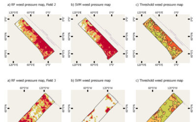
MSc thesis defense by Nestor Gualsaqui
On March 8th at 10:30 Nestor will present his M.Sc. thesis "Pre-crop emergence weed mapping using high satellite imagery". From the abstract: "During the last decades, the growth of the world population has been increasing and weather fluctuations around the world...

MSc defense Nils Karges
Nils Karges will present his M.Sc. thesis "Exploring spatial relationships of soundscape variables in urban areas. " on 15th of February at 9:30. From the abstract: "This work describes the relationship between soundscape and the underlying landscape in an urban...

MSc defense Camilo Zamora
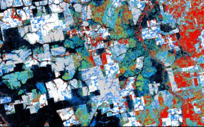
On Friday 11th of February at 9am Camilo Zamora will present his M.Sc. thesis "Deforestation dynamics in the Dry Chaco ecoregion: a three decades of change detection and fragmentation study analysis". From the abtract: "Tropical forests represent 52% of global forests...
MSc idea and interesting presentations
on Friday 18th of February at 9am we will have the following presentations: Jakob Rieser - Thesis Idea: "A Synergistic Use of Optical and SAR Remote Sensing Data for the Long-term Evolution of Biocrusts and their Activity across diverse Dryland Ecosystems"....
Internship, inno lab and MSc. idea
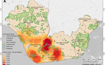
On Monday 17th of January at 9am we will have the following presentations: Luisa Pflumm (MSc. idea presentation): "Assess silver-backed chevrotaindistribution in Nui Chua NP (Vietnam).", supervisors: Insa Otte, Andreas Wilting (IZW) Christopher Chan (Msc. idea...
Our EAGLEs featured on the University page
Our EAGLEs Sofia, Annika, Antonio, Andreas and Nils are featured on the University webpage with their UrbanSens idea of combining mobile IoT sensors and Earth Observation data for urban climate monitoring. Their success winning the DLR Copernicus challenge rewarded...
MSc defense by Yomna Eid
Yomna will present her M.Sc. thesis "Assessment of ESA CCI+ and NASA MODIS-LST in Ecological Transects of Australia" on January 14th 2022 at 10am. From the abstract: "Identifying the best-performing MODIS LST products available for scientific analysis is instrumental...
MSc defense by Marius Witt
Marius Witt will present his M.Sc. thesis "Investigating discharge dynamics at catchment level usingremote sensing timeseries" on Friday 14th of January 2022 at 9am. From the abstract: The anthropogenic induced climate change is one of the foremost challenges of the...
Our students won the DLR Copernicus challenge 2021!
Great to see again our EAGLE students winning the DLR Copernicus challenge. Last year Henrik Fisser won with his truck detection approach, this year our EAGLE students Sofia Garcia, Annika Ludwig, Nils Karges, Andreas Bury and Antonio Castaneda won the DLR Copernicus...

Great dashboard by our EAGLE students
our EAGLE students created various informative remote sensing and spatial environmental data dashboards and learned a lot how to communicate their Earth Observation research in an interactive online platform. One example by our student Ronald Okoth is shown below and...