We are very proud to share the diverse submissions of spatial R packages within the EAGLE M.Sc. course of Ariane Droin and Martin Wegmann aiming at advancing our students’ knowlege about programming for environmental analysis, geospatial visualization, and ecological modeling. Below is a list of the packages submitted within the last EAGLE 1st semester programming course, each offering unique functionalities to support researchers and practitioners in various domains.
🌿 1. lcutils by Max Merzdorf
lcutils provides utility functions for land cover analysis, visualization, and general geospatial data handling. Notably, it includes the alluvial_pairs_diagram() function, which offers a visually appealing representation of land cover change over time, making it easier to interpret complex crosstables and change matrices.
🏙️ 2. ShadowMapR by Agnes Zwick
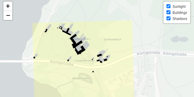
Designed for urban planning and solar analysis, ShadowMapR allows users to calculate and visualize building shadows based on sunlight exposure. It processes .xml or .gml files containing building geometries, computes solar positions, and generates interactive maps displaying sunlight and shadow areas using leaflet.
🌳 3. HedgeConnectivityPackage by Lukas Fronzeck
HedgeConnectivityPackage offers functions to calculate connectivity metrics for hedges and Small Woody Features (SWF), supporting ecological landscape analysis and conservation planning. It facilitates the creation and analysis of hexagonal grids, clipping and visualization of spatial data, and calculation of key connectivity metrics.
🔬 4. fiRes by Hanna Schulten
fiRes is designed for analyzing fire regimes, providing tools to assess fire frequency, intensity, and spatial patterns. This package aids in understanding fire dynamics and their ecological impacts, contributing to fire management and conservation efforts.
🧊 5. antarcticR by Sebastian Rothaug
antarcticR focuses on Antarctic research, offering functions to process and analyze environmental data from the polar region. It supports the study of climate change, glaciology, and biodiversity in Antarctica, facilitating data-driven insights into this critical area.
🌍 6. LandslideSusceptibilityR by Mahnoor Nadeem
This package provides tools for assessing landslide susceptibility, integrating geospatial data to model and predict areas at risk. It supports disaster risk reduction and land-use planning by identifying vulnerable zones.
🎬 7. animategee by Anita Dandekyha
animategee facilitates the creation of animated time-series visualizations from Google Earth Engine data. It simplifies the process of generating dynamic maps, enhancing the presentation of temporal changes in geospatial datasets.
🌊 8. FloodPack by Florian Dialer
FloodPack offers a suite of tools for flood risk assessment and management. It includes functions for hydrological modeling, floodplain mapping, and risk analysis, supporting flood mitigation strategies and urban planning.
📈 9. quickedaTS by Loan Thai
quickedaTS streamlines the exploratory data analysis process for time series data. It provides quick visualization and summary statistics, aiding in the initial assessment and understanding of temporal datasets.
🚢 10. shipdetectR by Clemens Schömig
shipdetectR focuses on detecting and analyzing ship movements using satellite imagery. It supports maritime monitoring, environmental impact assessments, and the study of shipping patterns.
🌲 11. paRks by Michael Gaston
paRks provides tools for analyzing and visualizing protected areas. It includes functions for spatial analysis, biodiversity assessment, and conservation planning, supporting the management of natural reserves.
🌐 12. LSdownloader by Mariam Ansah
LSdownloader simplifies the process of downloading Landsat imagery. It automates the retrieval of satellite data, facilitating remote sensing analysis and environmental monitoring.
🗺️ 13. geoRssistant by Jannis Midasch
geoRssistant assists in processing and visualizing geospatial data feeds, particularly RSS feeds with geographic information. It supports the integration of real-time data into geospatial analyses and applications.
📊 14. WSFCoRRelatoR by Niklas Treichel
WSFCoRRelatoR focuses on analyzing and visualizing water, soil, and forest data. It provides tools for assessing environmental conditions and trends, supporting sustainable land management practices.
🌊 15. algaepackage by Marine Lefranc
algaepackage offers functions for analyzing and visualizing algal data, supporting studies in marine biology and ecology. It aids in understanding algal blooms, biodiversity, and ecosystem health.
📉 16. chngTrackR by Rejina Gauro
chngTrackR provides tools for tracking and visualizing changes in environmental variables over time. It supports the analysis of temporal trends and patterns in ecological data.
🧪 17. R-Package2025 by Arthur Dreher
R-Package2025 is a comprehensive package offering a variety of functions for data analysis and visualization. It aims to streamline workflows and enhance
a full list:
Max Merzdorf https://github.com/max-merzdorf/lcutils
Agnes Zwick https://github.com/agneszwick/ShadowMapR
Lukas Fronzeck https://github.com/lukas-f00/HedgeConnectivityPackage
Hanna Schulten https://github.com/HannaZoe/fiRes
Sebastian Rothaug https://github.com/SebastianRothaug/antarcticR
Mahnoor Nadeem https://github.com/Mahnoor-Nadeem-1995/LandslideSusceptibilityR.git
Anita Dandekyha https://github.com/anitadandekhya/animategee.git
Florian Dialer https://github.com/FlorianDialer/FloodPack/
Loan Thai https://github.com/loanthai107/quickedaTS
Clemens Schömig https://github.com/clemensschoemig/shipdetectR
Michael Gaston https://github.com/Miner501/paRks
Mariam Ansah https://github.com/mariamansah/LSdownloader
Jannis Midasch https://github.com/JMidasch/geoRssistant
Niklas Treichel https://github.com/D4t4mur/WSFCoRRelatoR
Marine Lefranc https://github.com/marine08el/algaepackage
Rejina Gauro https://github.com/ReznaGauro/chngTrackR
Arthur Dreher https://github.com/Ar7hur01/R-Package2025
Wajiha Yasmeen https://github.com/WajihaYasmeen1/denscity
Anugraha Das https://github.com/AnugrahaDas1/HydroBasin
Madhura Saha https://github.com/MadhuraSaha02/leafMeAlone
Temesghen https:/github.com/Temesghen-Eyassu/LULCtoLST


