
On July 07, 2026, Farimah Abdolzadeh will present her Master Thesis on ” Evaluating Surface Urban Heat Islands in Bavarian Cities through a Multi-Variable Analysis ” at 13:00 at the seminar room 3 in John-Skilton-Str. 4a.
From the abstract: Surface Urban Heat Island (SUHI) research has focused mainly on large cities using non-spatial methods that ignore LST’s spatial structure. This study analyzes daytime LST across 100 Bavarian cities (large, medium, small) using MODIS (1 km) and Landsat 8 (100 m) data, comparing OLS and Spatial Lag Model (SLM) with four predictors: NDVI, albedo, distance to water, and building density.
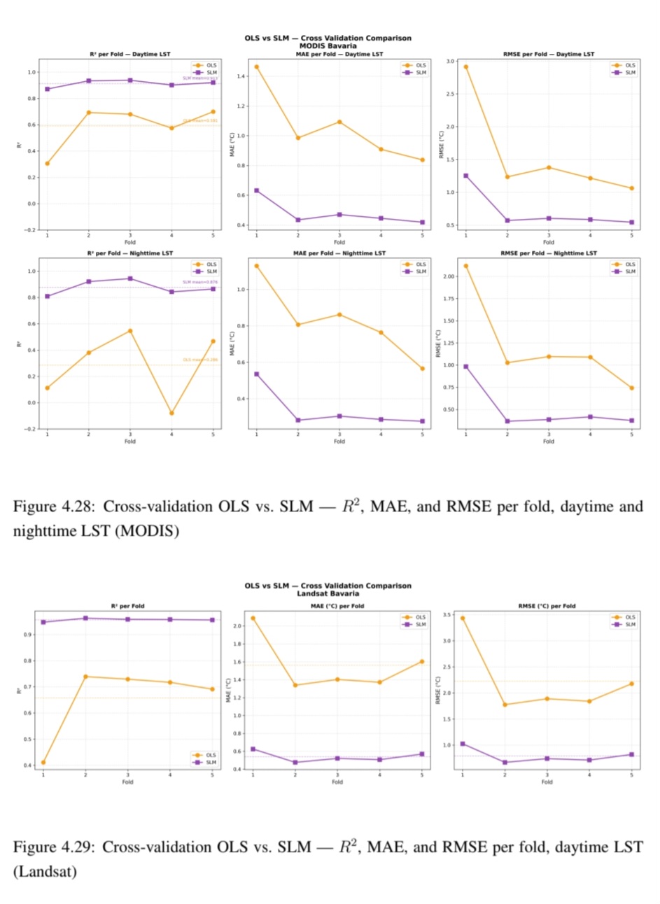
NDVI is the one of the strongest cooling factor and albedo the strongest heating factors. Building density consistently increases LST, while water’s cooling effect only appears at 100 m resolution. SLM substantially outperforms OLS, boosting cross-validation R² from 0.591 to 0.913 (MODIS) and 0.658 to 0.956 (Landsat), with greater gains at higher resolution, showing spatial regression matters more as resolution increases. A threshold analysis (Landsat) finds a 0.045 NDVI increase yields a 1°C LST reduction, an achievable target for urban greening.
This study offers a multi-city spatial regression analysis of SUHI across Bavarian urban scales, demonstrates the necessity of spatial methods for high-resolution LST modeling, and provides actionable greening thresholds for heat mitigation policy.
1st supervisor: Dr. John Friesen
2nd (external) supervisor: Prof. Dr. Hannes Taubenböck
From the abstract: Surface Urban Heat Island (SUHI) research has focused mainly on large cities using non-spatial methods that ignore LST’s spatial structure. This study analyzes daytime LST across 100 Bavarian cities (large, medium, small) using MODIS (1 km) and Landsat 8 (100 m) data, comparing OLS and Spatial Lag Model (SLM) with four predictors: NDVI, albedo, distance to water, and building density.
NDVI is the one of the strongest cooling factor and albedo the strongest heating factors. Building density consistently increases LST, while water’s cooling effect only appears at 100 m resolution. SLM substantially outperforms OLS, boosting cross-validation R² from 0.591 to 0.913 (MODIS) and 0.658 to 0.956 (Landsat), with greater gains at higher resolution, showing spatial regression matters more as resolution increases. A threshold analysis (Landsat) finds a 0.045 NDVI increase yields a 1°C LST reduction, an achievable target for urban greening.
This study offers a multi-city spatial regression analysis of SUHI across Bavarian urban scales, demonstrates the necessity of spatial methods for high-resolution LST modeling, and provides actionable greening thresholds for heat mitigation policy.
1st supervisor: Dr. John Friesen
2nd (external) supervisor: Prof. Dr. Hannes Taubenböck




![[Spotlight] Lecturer Spotlight: Julian Faeth](https://eagle-science.org/wp-content/uploads/2026/10/Julian_Faeth_EORC_EAGLE_2026-400x250.jpg)



