On October 22, 2025, Ariana Sofía Argüello Cordero will present her Master Thesis on ” Modeling Urban Heat Exposure and Vulnerability Integrating Citizen Science and VHR Remote Sensing” at 10:15 at the EORC Meeting Room (1st floor), John-Skilton-Str. 4a
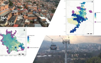
From the abstract: Global warming has increased the frequency, duration, and intensity of extreme heat events worldwide, with Europe warming at nearly twice the global average rate. In Germany, the summer of 2019 brought record-breaking temperatures exceeding 40 °C and more than 2,500 excess heat-related deaths. Given the importance of identifying local hotspots to guide specific mitigation measures and the density lack of traditional meteorological networks to capture fine-scale intra-urban variability, this study integrates outdoor citizen-science measurements from Netatmo weather stations, Luftdaten sensors, and research grade logger networks, in conjunction with very-high spatial resolution (VHR) remote sensing data as predictors for city-wide modelling of outdoor air temperature in the city of Augsburg, Germany. Statistical linear regression and machine-learning models were trained and evaluated using spatial cross-validation. Findings reveal strong intra-urban contrasts in thermal exposure. In 2019, average summer conditions exposed most residents to 21 °C, while the July heatwave increased exposures to 27–28 °C, with hotspots exceeding 30 °C, approximate 6°C increase in exposure compared to normal summer conditions. The approach was implemented with different spatial resolutions: 50 m grids captured local building and vegetation effects, while 100 m grids highlighted broader city-wide trends. Air temperature predictions combined with census data produced a Heat Vulnerability Index (HVI), linking heat exposure with social vulnerability. Overall, the study shows that citizen science data, despite limitations, can effectively complement traditional networks when integrated with VHR remote sensing. The approach is transferable to other cities, offering a scalable framework for high-resolution urban heat mapping to inform adaptation and protect vulnerable populations.
1st supervisor: Prof. Dr. Hannes Taubenböck 2nd (external) supervisor: Dr. Tobias Leichtle