
The following students will present next Tuesday (26th) at 2pm in room 0.004 their internships or innovation labs:
Itohan-osa Abu (internship):
Mangrove Mapping with TimeScan Data for Nigeria and an Analysis in Context of Coastal Gas Flaring
Salim Soltani (internship):
Comparative study of Snow Classification Accuracy using optical satellite data with different spatial resolution (MODIS, Landsat, Sentinel, Spot-V)
Sebastian Buchelt (innovation lab):
Processing & Validation of State-of-Art Snow Cover Extent Algorithms using Landsat 5/7/8 Time Series
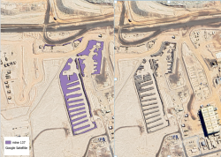
EAGLE Internship Presentation: Detection of OffRoad Tyre Dumpsites at Mining Operations Using Sentinel-2 Imagery and Deep Learning Segmentation
On July 21, 2026, Wajiha Yasmeen will present her internship results on " Detection of Off-The-Road Tyre Dumpsites at Mining Operations Using Sentinel-2 Imagery and Deep Learning Segmentation " at 12:00 at the seminar room 3 in John-Skilton-Str. 4a. From the abstract:...
![[spotlight] Lecturer Spotlight: Martin Wegmann](https://eagle-science.org/wp-content/uploads/2026/07/Martin_Wegmann_EAGLE_lecture_2026-400x250.jpg)


