On Friday, 1st of July at 9am Antonio will present his M.Sc. thesis “Potential and limits of using UAS in forest monitoring”.
From the abstract: “The exponential development, usage, and application of uncrewed area systems (UAS) have given remote scientists a clear opportunity to improve and complement fieldwork measurements and start interconnecting different spatial resolution products with field work expanding the analysis possibilities in broad ways. Even if UAS represents a hyper-local data set under the remote sensing view, it has also been a game-changer for above-ground biomass (AGB) estimations. Traditionally, direct measurements of AGB have been made through destructive methodologies that imply tree trunk, leaves, and branches harvesting making them time-consuming, labor-intensive, and impossible to cover large areas procedures. Despite that, nondestructive methods allow AGB estimations by using allometric equations. Those equations establish relationships between tree parameters such as tree height (H), crown diameter (CD), and diameter at breast height (DBH) and the total AGB of the tree. Although the AGB can be calculated by measuring these variables, obtaining them in the field for each tree is time-consuming and not systematic.
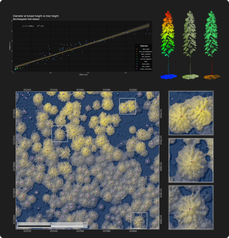
In this work, four Lidar point clouds obtained with UAS flights are obtained over a test plot in Berchtesgaden National Park, south Germany-Bavaria to compare the final AGB estimation from different flight heights (80 m and 100 m), flight directions East-West and North-South. The AGB is calculated using standard algorithms from the BIOMASS R package to standardize the outputs. The different settings, two different heights at two different flight directions (North-South and East-West), have a low impact on the single tree segmentation and point cloud density. Therefore, planning UAS missions at higher altitudes can be prioritized to encompass more areas. Also, certain conditions, such as the seasonality, should be met to ensure that enough laser beams impact the tree stems. Finally, the synergy between small field plot measurements and UAS overflights may represent one of the most accurate ways to expand the covered area by fieldwork and make the time series variable easily included in AGB data sets. Systematicity and reproducibility, which the UAS give, place them as valuable datasets to explore. Furthermore, they can be used to upscale analysis and generate highly comparable to ground truth data sets that may serve as control points for remote sensing AGB products. “
supervisors: Martin Wegmann, Mirjana Bevanda







![[spotlight] Lecturer Spotlight: Martin Wegmann](https://eagle-science.org/wp-content/uploads/2026/07/Martin_Wegmann_EAGLE_lecture_2026-400x250.jpg)