Pilar Endara Pinillos handed in her M.Sc. thesis “Flooding patterns and vegetation developments in the Orinoco flooded savannas of Colombia.”
Her M.Sc. defense will be on Wednesday 13th at 2pm in room 0.004 (OKW 86).
The ecosystems that are present within Colombian Orinoco flooded savannas are currently being threatened by conversion of natural systems into intensive rangelands with introduced pastures, croplands and palm oil plantations. The loss of natural floodplain ecosystems has serious negative impacts on several important ecosystem services such as habitat quality for biodiversity, long-term carbon sequestration and water regulation.
In addition, this region’s natural vegetation endures strong intra-annual hydrological regimes, which in turn may affect the productivity, and consequently, the region’s carbon dynamics.
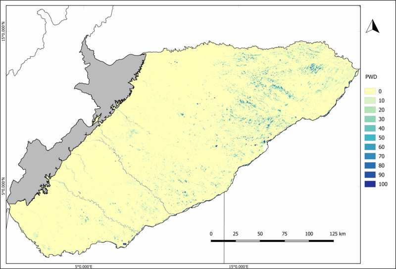
In order to understand the dynamics of vegetation productivity and its relationship with hydro-logical regimes this study presents an approach which uses Sentinel-1 and Sentinel-2 data for mapping temporal flood patterns and analyzing vegetation development according to these pat-terns and land cover in the year 2017. A flood map was created based on a combination of water masks derived with WaMaPro processor for Sentinel-1 data and with multi-threshold analysis for Sentinel-2. This map was used to assess potential differences in vegetation development -with NDVI as a proxy- of areas with differing flooding patterns and a Corine Land Cover map allowed to analyze these differences also by land cover.
The flood map allowed the separation of temporal water bodies and the understanding of the variability of vegetation development according to the highly variable water dynamics of the study region of Casanare in Colombia. Differences in the vegetation development were found among agriculture and natural grasslands. The NDVI of grasslands in areas that were flooded tended to maintain high values during the dry season while for agricultural areas the opposite behavior was found. These results demonstrate the importance of the savannas and grasslands of the Orinoco for the stability of the vegetation and its dependency on the flood dynamics.