Aim
The module addresses methods on how Earth Observation and the use of geoinformation can support different fields of land and water management. The students will be guided to gain knowledge in selected practical examples.
Content
A general introduction on the subject, which strongly integrates large fields of environmental sciences and studies, is given. The students select topics in which remote sensing and geoinformation can significantly contribute parameters for answering relevant management questions. The topics include the derivation and use of parameters for monitoring land and/or water resources and examples how they can actually implemented in analytical or predictive models, or in indicator systems. The examples may include the management of the resources in rangelands, croplands, irrigation and drainage systems, river catchments, urban areas, or others. Focus may be set on special geographical settings. Depending on the selected topics and scale relevant Earth Observation parameters can include land cover and land use mapping, biophysical variables (LAI/FPAR/Chlorophyll, evapotranspiration , etc.), biomass or crop yields, soil moisture, phenological metrics and other dynamic parameters.
Coding
Software
Techniques
Content
General Course News and Updates

M.Sc. defense by Jakob Rieser
On Monday, 26th of September at 10am, Jakob will present his M.Sc. thesis „A Synergistic Use of Optical and SAR Remote Sensing Data for the Long-term Evolution of Biocrusts and their Activity Across Diverse Dryland Ecosystems”. from the abstract: "Biological soil...

MSc defense by Christopher Chan
Chris will present his M.Sc. thesis "Investigating the capability of UAV imagery in AI-assisted mapping of Refugee Camps in East Africa" on Friday 16th of September at 2pm. From his abstract: " Refugee camps and informal settlements provide accommodation to some of...
MSc defense by Annika Ludwig
Annika will present her M.Sc. thesis "Analysis of alpine grassland management dynamics based on webcam and optical remote sensing time series" on Friday 9th of September at 9am. From the abstract: "The aim of this study is to detect relationships between environmental...

EAGLE summer dialogue 2022
After two years we finally had our EAGLE summer dialogue again with many Earth Observation alumni, now working in various research organizations and companies. Great to talk to all our past and present students and also seeing all the students getting to know each...
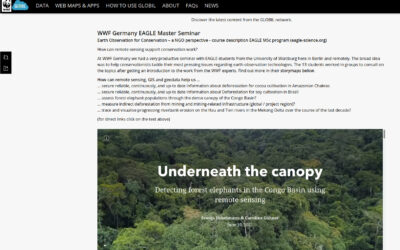
WWF course on applied Earth Observation
Our EAGLE students joint a course offered by the earth observation unit at WWF and learned how to apply remote sensing within a conservation NGO. They learned a lot and their results are published as story maps on their webpage...
Inno lab and internship presentations
On Friday, 8th of July, at 9:30 we will have the following presentations: Jana Maier (InnoLab at DLR): Multitemporal SAR Analysis for Sentinel-1 metrics based Land Cover Classification in West Africa - InnoLab in Agroecosystems and Phenology at DLR. Nora Nieskens...
MSc defense by Antonio Castaneda
On Friday, 1st of July at 9am Antonio will present his M.Sc. thesis "Potential and limits of using UAS in forest monitoring". From the abstract: "The exponential development, usage, and application of uncrewed area systems (UAS) have given remote scientists a clear...
internship, inno lab and MSc idea presentation
On Monday, 30th of May, from 10am onwards, we will have the following presentations: Ása Dögg (Inno-lab): "Potential of Sentinel-1 data for research and monitoring in Tröllaskagi peninsula, Iceland - Snow cover mapping using S-1 time series."Supervisors: Tobias...
Internship and Inno Lab presentations
On Friday 20th of May at 9am we will have the following internship and inno lab presentations: Andrea Cardenas (Internship at DLR): “Data analysis of the refugee crisis in West Africa and definition of test sites in NRW – Germany”supervisor: Martin Muehlbauer Ása Dögg...

EAGLE application in 2022
We received again more than 200 applicants from all over the world. In total applicants from 42 different countries applied to our international Earth Observation M.Sc. program, covering countries such as Hungary, Morocco, Malaysia, Kenya, Nepal or Columbia. We are...