Aim
This course provides detailed knowledge of programming or coding using spatial data, especially for remote sensing and GIS tasks.
Content
Different spatial programming approaches are covered using actual remote sensing and GIS data to enable the students to apply a variety of methods in a semi-automatic manner for remote sensing data analysis. All methods will be practically applied during the course using the programming language R and maybe other programs such as GRASS, SAGA, QGIS or OTB. This course continues where the “Programming and Geostatistics” courses stopped and is considered a prerequisite. Both courses are tightly linked
Coding
Software
Techniques
Content
General Course News and Updates
Internship Report on Tuesday, May 21st at 12:00
NEW DATE: On Tuesday, May 21st, Elly Schmid will present her internship at 12:00 in seminar room 3, John-Skilton-Str. 4a. : From the abstract: The internship was carried out as part of the HEATS-(Urban heat) Project of the Georisks team at the Earth Observation...
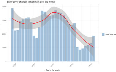
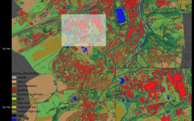
Spatial Earth Observation R packages by our EAGLEs
Our EAGLE students that took and passed our Introduction to spatial programming course had to submit an R package that applies spatial methods for a variety of Earth Observation data. We are very proud to show the huge diversity of very interesting and useful R...
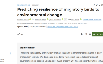
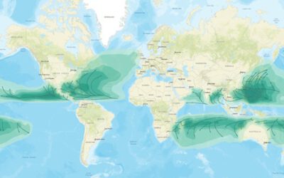
publication by our EAGLE Ben Lee
Our EAGLE Ben conducted an internship during his EAGLE studies which led to a new publication on "Predicting resilience of migratory birds to environmental change" jointly with the Alfred Wegener Institute Helmholtz Centre for Polar and Marine Research, Section Polar...

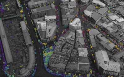
EAGLE student Konstantin Müller completed an internship at IRIDeS in Japan
Our EAGLE M.Sc. student Konstantin Müller successfully completed a three-month internship at The International Research Institute for Disaster Science (IRIDeS) in Japan. IRIDeS is a leading institute dedicated to advancing research and understanding in the field of...
Internship Presentation: Application of Geospatial Science in Reinsurance
On Tuesday, May 07, at 12:00 Ronja Seitz will present her internship presentation on "Application of Geospatial Science in Reinsurance " in seminar room 3, John-Skilton-Str. 4a. From the abstract: I used the opportunity of my mandatory internship to enter an entirely...
Internship Report on Tuesday, April 30 at 14:00
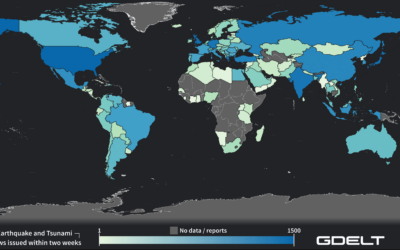
On Tuesday, April 30 Konstantin Müller will present his internship " GDELT News Analysis of the Noto Earthquake via ERNIE" at 14:00 in 01.B.03, John-Skilton-Str. 4a. : From the abstract: The analysis of socioeconomic data has gained increasing importance. The exchange...
EAGLE MSc. graduation
We are very happy to celebrate again the graduation of some of our EAGLE M.Sc. students. The candidates already handed in their M.Sc. thesis a while ago but just recently we had our EAGLE graduation party and enjoyed to celebrate this important milestone with all...
Master Thesis Defense: Unmasking the Shadow Economy in Ghana: Mapping The Distribution of Umbrella Covered Informal Vendors In Kumasi
On Tuesday, April 30, at 13:00 Prince Lartey Lawson will present his master thesis on " Unmasking the Shadow Economy in Ghana: Mapping The Distribution of Umbrella Covered Informal Vendors In Kumasi " in 01.B.03 Meeting Room 1st Floor, John-Skilton-Str. 4a. From the...
Master Thesis Defense: “Flood susceptibility mapping using remote sensing and geospatial data in West Africa “
On Tuesday, April 30, at 12:00 Wilmer Fabián Montién Tique will present his master thesis on " Flood susceptibility mapping using remote sensing and geospatial data in West Africa " in 01.B.03 Meeting Room 1st Floor, John-Skilton-Str. 4a. Abstract: Floods in West...

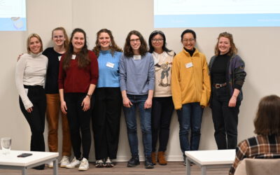
EAGLE workshop on Earth Observation application
Our first EAGLE workshop on Earth Observation applications covered various topics. After a heartily welcome by Tobias Ullmann did more than 50 participants listen to the following talks: Ása Aðalsteinsdóttir: “SAR Monitoring in Iceland” Katrin Wernicke:...