Lecturer
Julia Rieder
ECTS
5 ECTS
Aim
The course provides a practical introduction to LiDAR technology and point cloud analysis. Students gain hands-on experience with LiDAR data, from acquisition principles to processing and interpretation, and learn how LiDAR supports applications such as terrain modelling, forestry, and others. The course emphasizes critical understanding of data quality, limitations, and real-world use cases
Content
This course provides an overview of the scientific field surrounding LiDAR as a key technology for three-dimensional Earth observation. The course covers the fundamentals of LiDAR remote sensing, point cloud data structures, and processing methodologies across platforms ranging from spaceborne and airborne systems to terrestrial and mobile laser scanning. Furthermore, the course highlights current developments and emerging analytical possibilities enabled by advanced point cloud analysis and discusses future potential as LiDAR technologies and methodologies continue to evolve and converge with related disciplines.
Coding
Software
Techniques
Content
General Course News and Updates
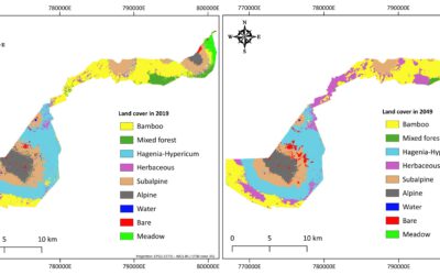
EAGLE MSc Defense “Utilizing deep learning and Earth Observation data to predict land cover changes in Volcanoes National Park, Rwanda”
On September 16, 2025, Jean de Dieu Tuyizere will present his Master Thesis on "Utilizing deep learning and Earth Observation data to predict land cover changes in Volcanoes National Park, Rwanda" at 12:00 in seminar room 3, John-Skilton-Str. 4a From the abstract:...
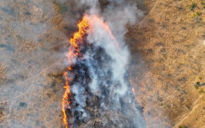
Mapping Fire from the Sky – Anna Bischof’s MSc Thesis on Savanna Fire Patterns
Wildfires are an essential ecological process in African savannas, shaping landscapes, influencing biodiversity, and playing a key role in nutrient cycling. Understanding their dynamics is crucial for both science and management – and this is where EAGLE MSc student...
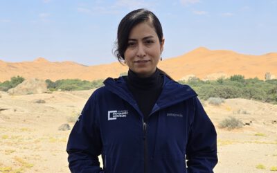
Exploring the Desert: Farimah’s Internship at Gobabeb in Namibia
We’re excited to share that our EAGLE MSc student, Farimah, is currently spending her internship at the renowned Gobabeb Namib Research Institute, nestled in the heart of the Namib Desert—one of the oldest and most unique desert ecosystems in the world. Farimah’s...

M.Sc. Student Clara Vydra Begins Thesis Field Work on Alpine Water Resources
We’re pleased to share that our M.Sc. student Clara Vydra has recently begun her thesis field work in the Austrian Alps in collaboration with the German Alpine Association (DAV) and the German Aerospace Center (DLR). Her research focuses on the impacts of climate...
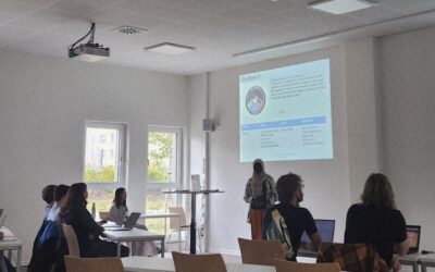
Future in Focus: EAGLE Students Host Mini-Symposium on Remote Sensing Innovations
In a spirited display of teamwork, scientific curiosity, and professional growth, our international MSc students from the EAGLE program recently organised and chaired their own scientific mini-symposium, showcasing the latest developments in remote sensing. The event...
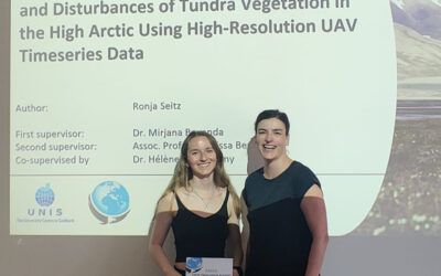
Successful MSc Thesis Defense by Ronja Seitz on UAV-Based Monitoring of High-Arctic Tundra Dynamics
We warmly congratulate Ronja Seitz on the successful defense of her MSc thesis, which tackled one of the most pressing environmental challenges of our time: the rapid warming of the high Arctic. Her research focused on Svalbard, one of the fastest-warming regions on...
🗺 Exploring Map Visualizations
Within our EAGLE courses our students have to learn a wide variety of skills - beside the fundamental earth observation theory and practice also skills like map creation is part of the curriculum. One of our students Ronja Seitz has created three visualizations guides...
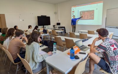
Course on Object-based image analysis
Dr. Michael Wurm from the German Aerospace Center (DLR) gave a class about Object-based image analysis (OBIA) using the eCognition Software for the EAGLE students. The course gives an insight into the theoretical basis of OBIA and using different datasets and tasks...

EAGLE Innolab Presentation “Earth observation data cube for the Volcanoes National Park, Rwanda”
On July 15, 2025, Jean de Dieu Tuyizere will present his Innolab results on " Earth observation data cube for the Volcanoes National Park, Rwanda" at 12:00 in seminar room 3, John-Skilton-Str. 4a. From the abstract: The increasing availability of Earth...

EAGLE Innolab Presentation “Earth observation data cube for the Volcanoes National Park, Rwanda”
On July 15, 2025, Jean de Dieu Tuyizere will present his Innolab on " Earth observation data cube for the Volcanoes National Park, Rwanda" at 12:00 in seminar room 3, John-Skilton-Str. 4a. From the abstract: The increasing availability of Earth observation (EO)...