Aim
Programming and geostatistics for environmental data analysis will be introduced. Advantages of coding approaches are discussed, theory of coding and statistics covered and practical examples provided.
Content
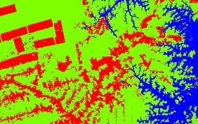
Theoretical basics and practical examples of programming and geostatistics focused on application within remote sensing and GIS are covered. Basic functionality such as script structure, implementation, functions, loops as well as programming syntax using the R language are introduced. Moreover, statistical basics related to environmental analysis are covered ranging from spatial queries to spatial models, e.g. classification and regression.
Coding
Software
Techniques
Content
General Course News and Updates
M.Sc. started on monitoring protected areas
Henrike Schulte to Bühne started her M.Sc. „Quantifying landcover change using remote sensing data in a transboundary protected area“ in cooperation with the Zoological Society of London, Dr. Nathalie Pettorelli within the Global Change Ecology study program. Her...
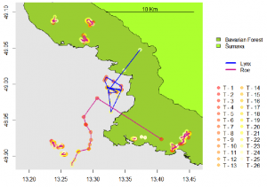
M.Sc. thesis on animal movement interactions and the environment
Joe Premier submitted his M.Sc. thesis on “The Lynx Effect: Behaviour of Roe Deer in the Presence of Lynx in a European Forest Ecosystem” within the Global Change Ecology M.Sc. program. He was co-supervised by Marco Heurich from the Bavarian Forest Nationalpark....
EAGLE news on DLR website
Our young EAGLEs are covered by the DLR news section! The news article covers the background of the EAGLE M.Sc. program and welcomes our new students. Great to see that our colleagues at DLR are looking forward to meet the new EAGLEs and are eager to have them as...
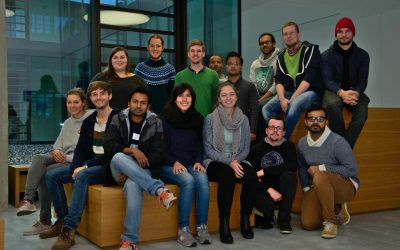
The 2016 EAGLEs
Our EAGLEs in 2016: Johannes Löw. Sarah Nolting, Marcus Groll, Bharath Selvaraj, Sebastian Roersch, Ahmed Saadallah, Marina Reiter, Pilar Endara Pinillos, Sazu Shahjahan, Ahmed Fowad, Jakob Schwalb-Willmann, Julia Sauerbrey, Louis Freytag, Karten Wiertz, Kamrul Islam...

EAGLE 2016 welcome
On Monday 17th of October we welcomed our new EAGLE students. The EAGLEs in 2016 are from Afghanistan, Bangladesh, Columbia, Egypt, India, Iran, Pakistan, Sweden and Germany. After the official welcome by all lecturer and the study program coordinator Christopher Conrad and the head of the remote sensing department and director of the DLR-DFD, Stefan Dech,
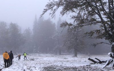
field course on remote sensing in the Bavarian Forest NP
The course on remote sensing for biodiversity analysis covered 10 days of field work, R coding, testing field methods such as UAVs and lots of hiking in the National Park Bavarian Forest. This year we had sunny and rainy weather and on the peaks also snow which made...
student perspective on the importance of remote sensing training
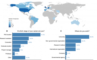
Some of our former M.Sc. students published a peer-reviewed article about the importance of remote sensing training approaches, how it helped them in their career and what need to be improved. The article is titled: “More than counting pixels – perspectives on the importance of remote sensing training in ecology and conservation” and published in Remote Sensing in Ecology and Conservation.

Winter term about to start
The winter term is about to start. The official start of the next semester is Monday 17th. The official EAGLE welcome will be on Monday as well followed by a joint dinner before the courses start on Tuesday. Further details on course dates and locations will be posted...

applications for 2016
The application deadline for the winter term 2016 was last Friday and we are now working through the numerous application. We are happy to have received a very high number of applications from all around the world and will get back to the applicants as soon as...

application opened for winter term 2016
The application is opened to apply for the EAGLE M.Sc. program starting this winter term 2016. The application deadline is July 15th 2016 (23:59, CEST). Please feel free to contact us beforehand to discuss open questions but please check our FAQ first. EAGLE is...