About
Claudia received her PhD in remote sensing from Vienna University of Technology in 2005 and is head of the department ‘Land Surface Dynamics’ at the German Earth Observation Center, EOC of the German Aerospace Center, DLR. The currently over 50 scientists of this department are involved in earth observation data analyses, monitoring dynamic processes of urban environments, forest ecosystems, agro-ecosystems, and the cryosphere; amongst others. The department contributes to over 30 third party funded remote sensing projects in different locations globally.
Claudias personal interest over the past years is on densely populated as well as natural coastal environments and river deltas. Claudia has coordinated (2008-2014) the German-Vietnamese WISDOM Project (Water related Information System for the sustainable Development of the Mekong Delta), the BMBF – MOST-CN funded DELIGHT Project (Delta Information System for Geoenvironmental and Human Habitat Transition in the Yellow River Delta, China), and has contributed and contributes to numerous other projects such as DeltaAdapt (BMBF), Sustainable DELTAS (Belmont Forum, DFG), PARLU (WWF, BMU), RCEIS (HGF), DONGTING (IB), RICEMAN (IB), CAWA (AA), DRAGON-4 and Carbon (KARI).
Claudia frequently lectures and has lectured for the Universities of Wuerzburg, Germany, Vienna University of Technology, Austria, the Chinese Academy of Sciences, CAS, the Vietnamese Academy of Sciences, VAST, and the European Space Agency, ESA. Claudia furthermore had a Visiting Professorship of the Chinese Academy of Sciences, CAS, from 2012 to 2016 at the Institute of Remote Sensing and Digital Earth, RADI-CAS, in Beijing, China. Claudia is head of the EARSeL Special Interest Group on Thermal Remote Sensing, and a Scientific Steering Committee member of Future Earth Coasts. She has authored and co-authored > 120 SCI journal papers, > 40 book chapters, and > 150 conference contributions, and has published three books with Springer. Claudia is Associate Editor of the International Journal of Remote Sensing, member of the Editorial Board of the journal Remote Sensing, and acts as a reviewer for 15 SCI journals from the field of remote sensing, environmental sciences, and geophysics. Next to applied remote sensing especially in the context of land use management and integrated water resources management, her current main research interest is on time series analyses, as well as on the linkage of natural and social sciences.

Prof. Dr. Claudia Kuenzer
Department of Remote Sensing, Univ. Wuerzburg
head of DLR-DFD LAX
Recent News

EAGLE Internship Presentation: Geomorphological Monitoring at Askja Caldera: Field Observations of Subsurface Instability
On April 28, 2026, Hanna Zoë Schulten will present her internship results on " Geomorphological Monitoring at Askja Caldera: Field Observations of Subsurface Instability" at 12:30 in seminar room 3, John-Skilton-Str. 4a. From the abstract: Volcanic calderas are...

From Data to Impact: Viktoria Veith’s Internship at WWF
Understanding the environmental consequences of conflict is one of the most pressing challenges in contemporary Earth observation. During her internship at WWF, EAGLE MSc student Viktoria Veith has been working at the intersection of remote sensing, policy, and...

EAGLE MSc Defense: Developing a Farmland Habitat Biodiversity Indicator for Bavaria (in line with OECD Guidelines)
On March 31, 2026, Suriya Elango will present his Master Thesis on " Developing a Farmland Habitat Biodiversity Indicator for Bavaria (in line with OECD Guidelines)" at 12:00 in seminar room 3, John-Skilton-Str. 4a. From the abstract: Farmland Biodiversity is...

EAGLE Innolab Presentation: Very high-resolution UAV-based Weed Segmentation: Data Processing, Modelling, and Exploration of Vision-Language Models for Agriculture
On April 28, 2026, Hanna Schulten will present her Innolab results on "Very high-resolution UAV-based Weed Segmentation: Data Processing, Modelling, and Exploration of Vision-Language Models for Agriculture" at 12:00 in seminar room 3, John-Skilton-Str. 4a. From the...

EAGLE MSc Defense: Assessing the potential of multispectral UAS and PlanetScope imagery for estimating vegetation structure and biodiversity metrics in urban green spaces
On March 27, 2026, Max Merzdorf will present his Master Thesis on " Assessing the potential of multispectral UAS and PlanetScope imagery for estimating vegetation structure and biodiversity metrics in urban green spaces" at 12:30 at the meeting room 01.B03 (first...

EAGLE Students in Kruger National Park: Internship at SANParks
EAGLE MSc students Sebastian Rothaug and Clemens Schömig are currently completing an internship/InnoLab with SANParks in Kruger National Park, South Africa. During their stay, they are contributing to a project on fire and drought dynamics in savanna ecosystems. Their...
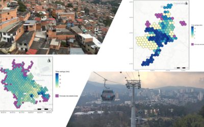
EAGLE MSc Defense: Assessing the accessibility improvements, public perception and potential beneficiaries of cable car systems in Mexico City and Medellin
On March 26, 2026 Angie Torres Lopez will present her Master Thesis on " Assessing the accessibility improvements, public perception and potential beneficiaries of cable car systems in Mexico City and Medellin" at 14:00 in seminar room 3, John-Skilton-Str. 4a. From...
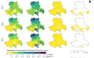
EAGLE MSc Defense: High-Resolution Seasonal Rangeland Carrying Capacity in Central Asia Using Sentinel-2 and the CASA Model
On March 19, 2026, Luis David Almeida Famada will present his Master Thesis on " High-Resolution Seasonal Rangeland Carrying Capacity in Central Asia Using Sentinel-2 and the CASA Model" at 15:00 in seminar room 3, John-Skilton-Str. 4a.High-Resolution Seasonal...
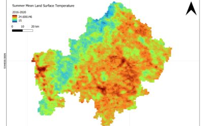
EAGLE MSc Defense: Satellite-Based Assessment of Geo-Climatic Variability in Lower Franconia: Identifying Climate-Related Risks
On March 18, 2026, Jyoti Biswas will present her Master Thesis on " Satellite-Based Assessment of Geo-Climatic Variability in Lower Franconia: Identifying Climate-Related Risks" at 13:00 in seminar room 3, John-Skilton-Str. 4a. From the abstract: The study examines...
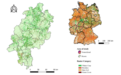
EAGLE Internship Presentation “Validation of High-Resolution Crop Classification Maps in Hessen Using IACS Parcel Data”
On March 24, 2026, Guisseppe Vasquez will present his internship results on " Validation of High-Resolution Crop Classification Maps in Hessen Using IACS Parcel Data " at 12:30 in seminar room 3, John-Skilton-Str. 4a.type of presentation: From the abstract: My...