Aim
Programming and geostatistics for environmental data analysis will be introduced. Advantages of coding approaches are discussed, theory of coding and statistics covered and practical examples provided.
Content
Theoretical basics and practical examples of programming and geostatistics focused on application within remote sensing and GIS are covered. Basic functionality such as script structure, implementation, functions, loops as well as programming syntax using the R language are introduced. Moreover, statistical basics related to environmental analysis are covered ranging from spatial queries to spatial models, e.g. classification and regression.
Coding
Software
Techniques
Content
General Course News and Updates
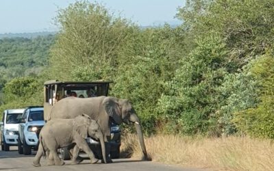
EAGLE Student Supports Savanna Monitoring in Kruger National Park
Our EAGLE M.Sc. student Lukas Fronzeck joined Luisa Pflumm, a former EAGLE and now PhD researcher at our Earth Observation Research Cluster (EORC), during fieldwork in Kruger National Park in South Africa. The field campaign forms part of Luisa’s PhD project...
![FW: [EORC Talk] Pathways towards a Healthy City – 10 March 2026, 03 pm](https://eagle-science.org/wp-content/uploads/2026/03/image001.jpg)
FW: [EORC Talk] Pathways towards a Healthy City – 10 March 2026, 03 pm
Dear colleagues and EAGLE students, This is a quick reminder to attend today’s and tomorrow’s EORC Talks, both at 3 p.m. sharp. TODAY 📍 What: EORC Talk on “Pathways towards a Healthy City” (Blog) 📍 Who: Christian Werthmann and Christian Corral...
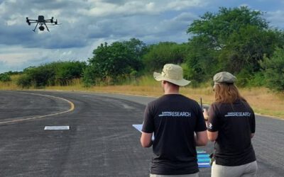
EAGLE Students Calibrate Thermal Sensors for Fire Mapping in Kruger National Park
Fieldwork, international collaboration, and hands-on sensor calibration – three EAGLE M.Sc. students recently experienced all of this during their internship in Kruger National Park in South Africa. Clemens, Sebastian, and Lukas are currently supporting an ongoing...
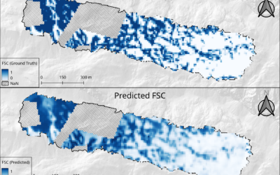
EAGLE Innolab Presentation: “From UAV to Satellite: Fractional Snow Cover Estimation at Sentinel-2 Resolution”
On March 03, 2026, Lutz Kleemann will present his Innolab results on "From UAV to Satellite: Fractional Snow Cover Estimation at Sentinel-2 Resolution" at 12:00 in seminar room 3, John-Skilton-Str. 4a. From the abstract: Fractional Snow Cover (FSC) estimation is an...
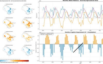
EAGLE Internship Presentation “Stream flow assessment and Irrigation demand in Central Asia (Aral Sea)”
On February 05, 2026, Anugraha Das will present her internship results on " Stream flow assessment and Irrigation demand in Central Asia (Aral Sea )" at 12:00 in seminar room 3, John-Skilton-Str. 4a. From the abstract: This presentation assesses streamflow dynamics...
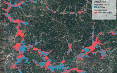
EAGLE Internship Presentation “Recommended Practices for Urban Flood Mapping in Emergency Response”
On February 10, 2026, Laura Obrecht will present her internship results on " Recommended Practices for Urban Flood Mapping in Emergency Response" at 12:00 in seminar room 3, John-Skilton-Str. 4a.type of presentation: From the abstract: Flood detection in urban...
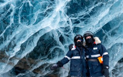
EAGLE Internship Presentation ” Internship on Svalbard”
On February 24, 2026, Leonie Sonntag and Jannis Midasch will present their internship results on " Internship on Svalbard" at 13:00 in seminar room 3, John-Skilton-Str. 4a. From the abstract: During March and April 2025, the two EAGLE students Leonie Sonntag and...

Across Cohorts and Borders: EAGLE Students Celebrate the Winter Term Together
As the winter term ends, the international students of our EAGLE M.Sc. programme gathered for an evening that was less about deadlines and data and more about community. After months of intensive coursework and research, the celebration offered a warm pause in their...
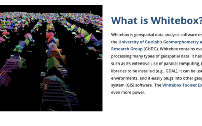
Learning Geospatial Tools in Practice: whitebox
A central goal of the EAGLE Earth Observation programme is to equip students with a broad and practical understanding of the software tools used in geospatial analysis. Rather than focusing on a single platform, students are encouraged to explore different approaches,...
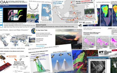
Mapping Disasters from Space: Inside the EAGLE MSc Course on Natural Hazards
From raging wildfires to devastating floods, natural hazards are becoming more frequent, more intense, and harder to predict. In this rapidly changing world, the ability to understand disasters as they unfold is no longer optional—it’s essential. This is exactly where...