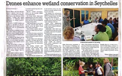
Our EAGLE student Jannis Midasch presented his work on “Rediscovering a lost medieval castle using GIS and UAS-based remote sensing” at the Annual Meeting of the Aerial Archaelogy Research Group in York, UK this September.
Jannis used various UAS/drone based approaches to map remnants of building structure on the ground. These patterns are hardly visible from the ground and just via the usage of UAS sensors and various analytical processing steps he was able to proof the existence of a former castle and could map the shape of the buildings.
It is a very interesting research he achieved during his BSc to use UAS sensors for archaelogical research.