
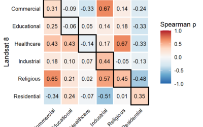
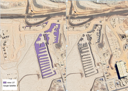
EAGLE MSc students recently showcased their research findings on snow depth and its driving factors at the Schneefernerhaus Environmental Research Station on Zugspitze, Germany’s highest peak. Their work, conducted under the supervision of PhD students Elio Rauth and Basil Tufail, is part of the EORC UAS team’s ongoing efforts to advance environmental monitoring through Unoccupied Aerial Systems (UAS).
Cutting-Edge Data Collection at High Altitude
Using state-of-the-art drone technology, the students carried out high-resolution UAS data acquisition over the snow-covered terrain. Their analysis focused on measuring snow depth variations and identifying key influencing factors such as temperature, wind patterns, and solar radiation. The project contributes to a better understanding of alpine snow dynamics, which are critical for climate studies, hydrology, and avalanche risk assessment.
Presenting Findings at Schneefernerhaus
The students presented their preliminary results to fellow researchers at EORC. Their work highlights the potential of UAS-based remote sensing in improving the accuracy and efficiency of snow monitoring compared to traditional methods. The collaborative environment at Schneefernerhaus allowed for insightful discussions, further refining their approaches for future research.
Strengthening UAS Applications in Environmental Science
This field study is part of the EORC UAS team’s broader mission to integrate drone-based remote sensing into environmental and climate research. Our EAGLE MSc students will continue to acquire more data and explore other approaches of in-situ measurements and UAS applications, paving the way for more innovative, data-driven approaches in alpine research.
The EAGLE program remains committed to equipping students with hands-on experience in cutting-edge geospatial technologies, preparing them for impactful careers in environmental research and beyond.
Stay tuned for more updates on our students’ exciting research adventures!
![[spotlight] Lecturer Spotlight: Martin Wegmann](https://eagle-science.org/wp-content/uploads/2026/07/Martin_Wegmann_EAGLE_lecture_2026-400x250.jpg)


