 Analyzing species-environment interaction is feasible using various data and method. An increasing technology is the tracking of animals and especially its linkage to remote sensing, as covered in AniMove.org. However, with this technology new challenges have to be dealt with, e.g. the decrease in accuracy of tracking devices in dense vegetation. In this innovation laboratory you can explore the error margins of tracking devices in relation to the landcover and explore options to solve it and being able to provide new improved methods to link animal movement data and remotely sensed environmental information.
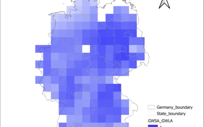
EAGLE Internship Presentation: Groundwater Level Trends in Germany: A National-Scale Assessment Using In-Situ Monitoring Data and GRACE Satellite Products
On August 04, 2026 Anugraha Das will present her internship results on " Groundwater Level Trends in Germany: A National-Scale Assessment Using In-Situ Monitoring Data and GRACE Satellite Products" at 12:00 at the seminar room 3 in John-Skilton-Str. 4a. From the...
![[spotlight] Lecturer Spotlight: Martin Wegmann](https://eagle-science.org/wp-content/uploads/2026/07/Martin_Wegmann_EAGLE_lecture_2026-400x250.jpg)


