About
Courses
- Advanced spatial python
- Urban forms & society

Recent News
EAGLE MSc Defense: Satellite-Based Assessment of Geo-Climatic Variability in Lower Franconia: Identifying Climate-Related Risks
On March 18, 2026, Jyoti Biswas will present her Master Thesis on " Satellite-Based Assessment of Geo-Climatic Variability in Lower Franconia: Identifying Climate-Related Risks" at 13:00 in seminar room 3, John-Skilton-Str. 4a. From the abstract: The study examines...
EAGLE Internship Presentation “Validation of High-Resolution Crop Classification Maps in Hessen Using IACS Parcel Data”
On March 24, 2026, Guisseppe Vasquez will present his internship results on " Validation of High-Resolution Crop Classification Maps in Hessen Using IACS Parcel Data " at 12:30 in seminar room 3, John-Skilton-Str. 4a.type of presentation: From the abstract: My...
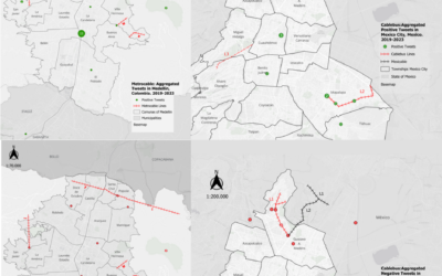
EAGLE Innolab Presentation: People’s Perception of Cable Car Transportation Using Twitter Data
On March 24 2026, Angie Torres will present her Innolab results on " People's Perception of Cable Car Transportation Using Twitter Data" at 12:00 in seminar room 3, John-Skilton-Str. 4a. From the abstract: Urban mobility is commonly analysed through geospatial methods...
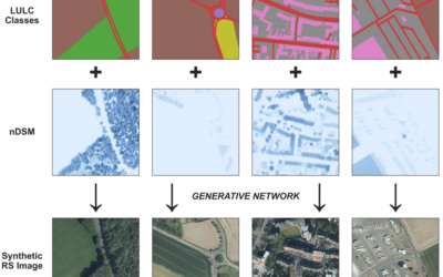
EAGLE MSc Defense: Synthetic High-Resolution Remote Sensing Image Generation – A Comparative Study of Model Training, Surface Data Variability and Evaluation Metrics
On March 26, 2026, Georg Starz will present his Master Thesis on " Synthetic High-Resolution Remote Sensing Image Generation – A Comparative Study of Model Training, Surface Data Variability and Evaluation Metrics" at 10:00 in seminar room 3, John-Skilton-Str. 4a....
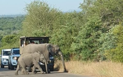
EAGLE Student Supports Savanna Monitoring in Kruger National Park
Our EAGLE M.Sc. student Lukas Fronzeck joined Luisa Pflumm, a former EAGLE and now PhD researcher at our Earth Observation Research Cluster (EORC), during fieldwork in Kruger National Park in South Africa. The field campaign forms part of Luisa’s PhD project...
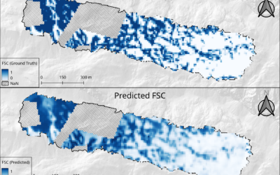
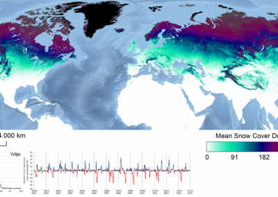
EAGLE Innolab Presentation: “From UAV to Satellite: Fractional Snow Cover Estimation at Sentinel-2 Resolution”
On March 03, 2026, Lutz Kleemann will present his Innolab results on "From UAV to Satellite: Fractional Snow Cover Estimation at Sentinel-2 Resolution" at 12:00 in seminar room 3, John-Skilton-Str. 4a. From the abstract: Fractional Snow Cover (FSC) estimation is an...
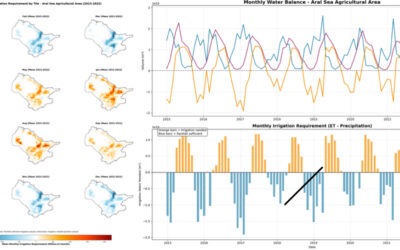
EAGLE Internship Presentation “Stream flow assessment and Irrigation demand in Central Asia (Aral Sea)”
On February 05, 2026, Anugraha Das will present her internship results on " Stream flow assessment and Irrigation demand in Central Asia (Aral Sea )" at 12:00 in seminar room 3, John-Skilton-Str. 4a. From the abstract: This presentation assesses streamflow dynamics...
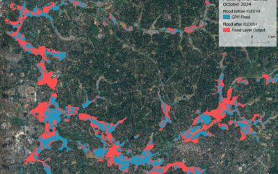
EAGLE Internship Presentation “Recommended Practices for Urban Flood Mapping in Emergency Response”
On February 10, 2026, Laura Obrecht will present her internship results on " Recommended Practices for Urban Flood Mapping in Emergency Response" at 12:00 in seminar room 3, John-Skilton-Str. 4a.type of presentation: From the abstract: Flood detection in urban...
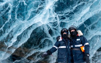
EAGLE Internship Presentation ” Internship on Svalbard”
On February 24, 2026, Leonie Sonntag and Jannis Midasch will present their internship results on " Internship on Svalbard" at 13:00 in seminar room 3, John-Skilton-Str. 4a. From the abstract: During March and April 2025, the two EAGLE students Leonie Sonntag and...
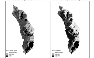
EAGLE Innolab Presentation: “Gap-Filling Optical NDVI Using SAR-Derived Indices and Machine Learning”
On February 10, 2026, Mahnoor Nadeem will present her Innolab results on " Gap-Filling Optical NDVI Using SAR-Derived Indices and Machine Learning" at 12:00 in seminar room 3, John-Skilton-Str. 4a. From the abstract: Normalized Difference Vegetation Index (NDVI) is...