Aim
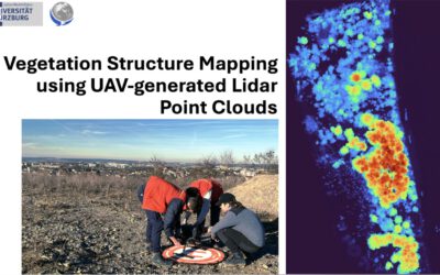
In this module you will gain a detailed understanding of the advantages and challenges of Earth observation using Light Detection and Ranging (LiDAR) systems. Compared to other types of remote sensing data, the data from active Light Detection and Ranging (LiDAR) systems is of particular importance for local studies, where the 3D component (height) of objects is of relevance. Commonly LiDAR data is applied it in the field of digital terrain modelling, in forestry – e.g. for canopy height assessment, or urban structure applications. LiDAR embraces a range of active remote sensing systems mounted on different platforms, which provide valuable information for characterization of horizontal and vertical structure of the earth surface by measuring the travel time of laser pulses in visible and near-infrared spectral domains. The quality of scanning depends on the nature of the LIDAR system (discrete-return or full waveform) as well as on a set of other terrain- and data-driven factors. This course provides you with an overview on the theory and applications of LiDAR data, with a particular focus on airborne laser scanning. Following the initial theoretical sections on the principles and basic characteristics of LiDAR data, diverse practical steps and exercises will be implemented to provide real-world examples to illustrate how the LiDAR point clouds can be applied to extract information on terrain, surface and vegetation. These information will be further employed to model vegetation structural attributes on multiple spatial scales ranging from single trees to landscape levels.
Content
Block 1: Introduction to LiDAR (how does laser scanning work?)
- Reminder on general remote sensing issues: difference between active and passive sensing
- History of LiDAR measurements
- Basics of LiDAR data measurements (platforms, sensors)
- Airborne vs. spaceborne LiDAR: history, applications and data access
- Measurement of travel time of laser light (pulsed time of flight)
- On the concept of “structure”: why a third dimension is crucial?
Block 2: Principles of LiDAR measurements
- Platform navigation, orientation and positioning
- Difference between types of data acquisitions: discrete return and echo waveform
- The recorded parameters: elevation, height, signal intensity and co.
- The concept of „single-pulse“ vs. „multiple-pulse“
- How are the incoming returns recorded? first come- first served!
- Terrestrial LiDAR measurement: one position, rotating scanner
- Data formats and big data-management: each byte matters!
Block 3: Elevation models:
- General thoughts: why are the elevation models essential?
- Digital terrain models
- Digital surface models
- Normalized DSM (Canopy height models)
- Application fields: Forest, landscape and habitat representations
- Magnified focus on Forest (basic and derived parameters): Diameter at breast height, height, tree type proportions, tree type mapping, crown closure, stem count, growing stock und aboveground biomass
- Single tree measurements
- Urban: City models, roof top and building footprints
Block 4: Exercises in Open-Source domain of LiDAR data processing (Fusion/LDV, LASTools, R)
- Exercises on point cloud processing
- Import, export, visualizations and rendering
- Sample measurements, single tree measurements and associated tasks
- Elevation models
- Data trimming, cropping, smoothing and generalizing
- Catalog and descriptive communication
- Extraction of metrics for modeling purposes
- Thoughts on metrics
- Intensity: yes or no?
- Multi-scale metric extraction
- Multi-source metric extraction
- Class works and workshops (CIP-Pool/Homework)
- Literature review, discussion groups and public presentations
Coding
Coding examples and individual work will be covered
Software
Various software programs will be used, but mainly OpenSource software such as R.
Techniques
Different techniques will be introduced and practically applied.
Content
The content of scientific with regard to the audience will be discussed.
General Course News and Updates
Behind the Lens: EAGLE Students Marlene & Anna Took Over Uni Würzburg’s Instagram!
What happens when two passionate Earth Observation students take the reins of the University of Würzburg’s Instagram account? A few days full of inspiration, insights, and a whole lot of drone footage! 🌍🚁 EAGLE MSc students Marlene and Anna recently...
Spatial R Packages Showcase by our EAGLE students
We are very proud to share the diverse submissions of spatial R packages within the EAGLE M.Sc. course of Ariane Droin and Martin Wegmann aiming at advancing our students' knowlege about programming for environmental analysis, geospatial visualization, and ecological...
EAGLE Master Defense: Deep Learning-driven SAR Image Super-Resolution
On May 20, 2025, Janik Hoffmann will present his Master thesis on Deep Learning-driven SAR Image Super-Resolution" at 13:00 in seminar room 3, John-Skilton-Str. 4a. From the abstract: Synthetic Aperture Radar (SAR) is a microwave remote sensing system that is used for...
EAGLE Master Defense: Spatio-temporal Forest Structure Dynamics in Germany: A Synthesis of Remote Sensing Products
On May 20, 2025, Sunniva McKeever will present her Master thesis on " Spatio-temporal Forest Structure Dynamics in Germany: A Synthesis of Remote Sensing Products" at 12:00 in seminar room 3, John-Skilton-Str. 4a. From the abstract: Germany’s forests have experienced...
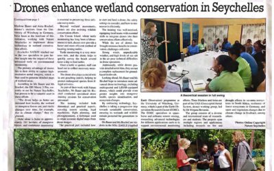
News article: EAGLEs Use Drones for Innovative Conservation Efforts in Seychelles
The work by our interns Anna and Marlene was covered in Seychelles Newspaper. The articles covers how Anna and Marlene successfully utilized drone technology to monitor and assess wildlife and environmental health across the archipelago. Their efforts, supervised by...
Unlock the Power of Earth Observation: Join Our MSc Program to Understand and Protect Our Planet
Are you passionate about understanding the planet's complex systems? Do you want to learn how to apply cutting-edge Earth Observation technologies to address some of the most pressing environmental and societal challenges of our time? If so, our EAGLE MSc in Applied...
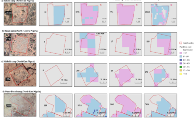
EAGLE Master Theses defense “Revealing Inconsistencies in Population Datasets in Refugee and IDP Camps”
On April 03, 2025, Lallu Nikerthil Prathapan will present her Master Thesis " Revealing Inconsistencies in Population Datasets in Refugee and IDP Camps " at 15:00 in seminar room 3, John-Skilton-Str. 4a. From the abstract: Accurate population estimates are crucial for...
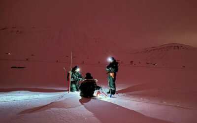
EAGLE MSc Students Present UAS-Based Snow Research at Zugspitze
EAGLE MSc students recently showcased their research findings on snow depth and its driving factors at the Schneefernerhaus Environmental Research Station on Zugspitze, Germany’s highest peak. Their work, conducted under the supervision of PhD students Elio Rauth and...

EAGLE Students Marlene Bauer and Anna Bischof to Participate in ISRSE 2025
We are very pleased to share that two of our students, Marlene Bauer and Anna Bischof, will be actively contributing to the International Symposium on Remote Sensing of Environment (ISRSE) 2025 in the UK next week. As part of their involvement with talks and posters,...
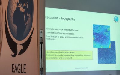
course on Theory and Practice of UAS Operation and Methods
Last week our staff members Antonio Gomez Castaneda and Luisa Pflumm did an UAS course within out EAGLE M.Sc. program. The primary objective of this course is to prepare students — from having no prior experience — to safely operate drones for scientific applications....