About
Dr. Martin Bachmann is research scientist with the Applied Spectroscopy Group at the German Remote Sensing Data Center, German Aerospace Center (DLR), Wessling, Germany. He has over 10 years of experience in the fields of hyperspectral data analysis and data pre-processing. For 8 years he was in charge of the data pre-processing chain of DLR’s Optical Airborne Remote Sensing and Calibration Facility (OpAiRS). He leads the work package on “Data Quality Control’ within the EnMAP ground segment, and is involved in the FP7 EUFAR Joint Research Activity on Data Quality Control for airborne hyperspectral and LiDAR pre-processing. In addition, he is also involved in the pre-processing of NOAA AVHRR time series within DLR’s TIMELINE project, and was involved within ESA CCI “fire” within the same field of activity. His research interests also include the development and application of spectral unmixing approaches, and algorithm developments towards the derivation of soil parameters using field, laboratory and airborne spectroscopy. His teaching and training experience is focusing on field and imaging spectroscopy, and includes courses at the Universities of Wuerzburg and Jena, within FP6 Marie Curie Project “Hyper-I-Net”, for Carl-Cranz-Gesellschaftand within DLR capacity building activities.
Courses

Recent News

EAGLE MSc Defense: Assessing the potential of multispectral UAS and PlanetScope imagery for estimating vegetation structure and biodiversity metrics in urban green spaces
On March 27, 2026, Max Merzdorf will present his Master Thesis on " Assessing the potential of multispectral UAS and PlanetScope imagery for estimating vegetation structure and biodiversity metrics in urban green spaces" at 12:30 at the meeting room 01.B03 (first...

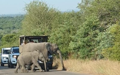
EAGLE Students in Kruger National Park: Internship at SANParks
EAGLE MSc students Sebastian Rothaug and Clemens Schömig are currently completing an internship/InnoLab with SANParks in Kruger National Park, South Africa. During their stay, they are contributing to a project on fire and drought dynamics in savanna ecosystems. Their...
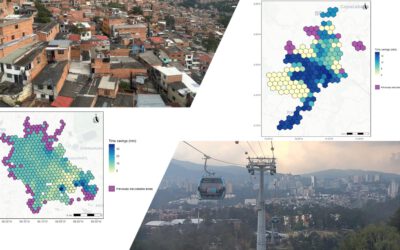
EAGLE MSc Defense: Assessing the accessibility improvements, public perception and potential beneficiaries of cable car systems in Mexico City and Medellin
On March 26, 2026 Angie Torres Lopez will present her Master Thesis on " Assessing the accessibility improvements, public perception and potential beneficiaries of cable car systems in Mexico City and Medellin" at 14:00 in seminar room 3, John-Skilton-Str. 4a. From...
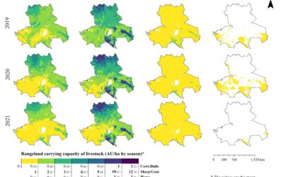
EAGLE MSc Defense: High-Resolution Seasonal Rangeland Carrying Capacity in Central Asia Using Sentinel-2 and the CASA Model
On March 19, 2026, Luis David Almeida Famada will present his Master Thesis on " High-Resolution Seasonal Rangeland Carrying Capacity in Central Asia Using Sentinel-2 and the CASA Model" at 15:00 in seminar room 3, John-Skilton-Str. 4a.High-Resolution Seasonal...
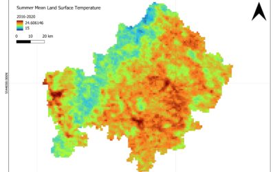
EAGLE MSc Defense: Satellite-Based Assessment of Geo-Climatic Variability in Lower Franconia: Identifying Climate-Related Risks
On March 18, 2026, Jyoti Biswas will present her Master Thesis on " Satellite-Based Assessment of Geo-Climatic Variability in Lower Franconia: Identifying Climate-Related Risks" at 13:00 in seminar room 3, John-Skilton-Str. 4a. From the abstract: The study examines...
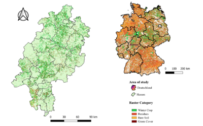
EAGLE Internship Presentation “Validation of High-Resolution Crop Classification Maps in Hessen Using IACS Parcel Data”
On March 24, 2026, Guisseppe Vasquez will present his internship results on " Validation of High-Resolution Crop Classification Maps in Hessen Using IACS Parcel Data " at 12:30 in seminar room 3, John-Skilton-Str. 4a.type of presentation: From the abstract: My...
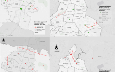
EAGLE Innolab Presentation: People’s Perception of Cable Car Transportation Using Twitter Data
On March 24 2026, Angie Torres will present her Innolab results on " People's Perception of Cable Car Transportation Using Twitter Data" at 12:00 in seminar room 3, John-Skilton-Str. 4a. From the abstract: Urban mobility is commonly analysed through geospatial methods...
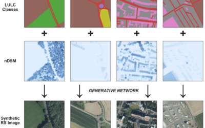
EAGLE MSc Defense: Synthetic High-Resolution Remote Sensing Image Generation – A Comparative Study of Model Training, Surface Data Variability and Evaluation Metrics
On March 26, 2026, Georg Starz will present his Master Thesis on " Synthetic High-Resolution Remote Sensing Image Generation – A Comparative Study of Model Training, Surface Data Variability and Evaluation Metrics" at 10:00 in seminar room 3, John-Skilton-Str. 4a....
EAGLE Student Supports Savanna Monitoring in Kruger National Park
Our EAGLE M.Sc. student Lukas Fronzeck joined Luisa Pflumm, a former EAGLE and now PhD researcher at our Earth Observation Research Cluster (EORC), during fieldwork in Kruger National Park in South Africa. The field campaign forms part of Luisa’s PhD project...
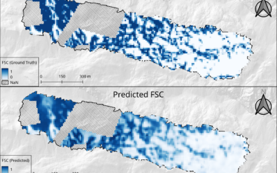
EAGLE Innolab Presentation: “From UAV to Satellite: Fractional Snow Cover Estimation at Sentinel-2 Resolution”
On March 03, 2026, Lutz Kleemann will present his Innolab results on "From UAV to Satellite: Fractional Snow Cover Estimation at Sentinel-2 Resolution" at 12:00 in seminar room 3, John-Skilton-Str. 4a. From the abstract: Fractional Snow Cover (FSC) estimation is an...