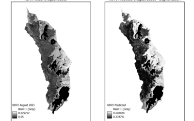
Actual evapotranspiration (ETact) is an essential component of the water balance and its determination for large areas is difficult on regional scale and can be explored within an innovation laboratory. The use of remote sensing data to determine ETact is particularly suitable to provide area based indicators for the evaluation of the efficiency and productivity of irrigation systems. Seasonal analysis of ETact is hampered by either spatial (MODIS) or temporal (Landsat) resolution. In order to provide a high-resolution (temporal and spatial) and dense remote sensing dataset Landsat and MODIS data will be fussed using the ESTARFM algorithm.
EAGLE Internship Presentation “Stream flow assessment and Irrigation demand in Central Asia (Aral Sea)”
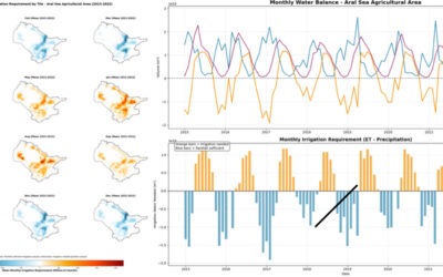
On February 05, 2026, Anugraha Das will present her internship results on " Stream flow assessment and Irrigation demand in Central Asia (Aral Sea )" at 12:00 in seminar room 3, John-Skilton-Str. 4a. From the abstract: This presentation assesses streamflow dynamics...