Aim
In this seminar, we cover most aspects of remote sensing based assessment of Land Surface Dynamics. Topics such as snow cover dynamics, water body dynamics, forest cover and further vegetation dynamics, urbanization dynamics, coastal dynamics, or dynamics of geophysical parameters such as land surface temperature or selected indices will be addressed. In this contexts we look at opportunities arising from optical-, multi-spectral- and radar sensors, as well as thermal imagery. Data availability and access, as well as typical software tools for the handling of multispectral data or time-series analyses will be addressed as well. The course will consist of a theoretical part and a practical part, where the theory consists of a seminar (written seminar and presentation on a topic to be chosen from a list of available topics), and where the practical will consist of data processing examples.
Content
Topics cover most aspects of remote sensing based assessment of Land Surface Dynamics. Topics such as snow cover dynamics, water body dynamics, forest cover and further vegetation dynamics, urbanization dynamics, coastal dynamics, or dynamics of geophysical parameters such as land surface temperature or selected indices will be addressed. We adress questions such as climate change induced shifts of snow or rainy seasons, look at patterns of forest loss and degradation over time, analyze urbanization patterns and impacts of these processes on the natural environment, and assess changes in coastal morphology. Sensors in focus will be the ones allowing for long time series analyses, such as AVHRR, MODIS, ENVISAT, Landsat, TerraSAR-X, and the Sentinel Satellites.
Coding
Software
Techniques
Content
General Course News and Updates
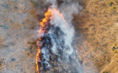
EAGLE Internship Presentation “Detecting Wildfires in Brandenburg, Germany”
On November 18, 2025, Angie Torres will present her internship at " Detecting Wildfires in Brandenburg, Germany" at 12:00 in seminar room 3, John-Skilton-Str. 4a. From the abstract: Wildfires have become an increasing concern in Germany, particularly in the region of...
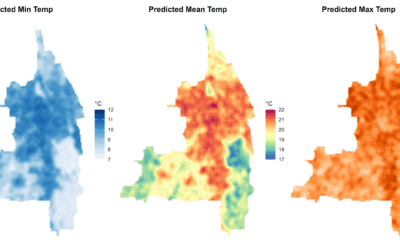
EAGLE MSc Defense “Modeling Urban Heat Exposure and Vulnerability Integrating Citizen Science and VHR Remote Sensing”
On October 22, 2025, Ariana Sofía Argüello Cordero will present her Master Thesis on " Modeling Urban Heat Exposure and Vulnerability Integrating Citizen Science and VHR Remote Sensing" at 10:15 at the EORC Meeting Room (1st floor), John-Skilton-Str. 4a From the...
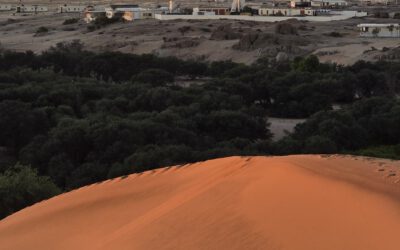
EAGLE Internship Presentation “Gobabeb Namib Research Institute”
On October 21, 2025, Farimah Abdolzadeh will present her internship at " Gobabeb Namib Research Institute " at 12:30 in seminar room 3, John-Skilton-Str. 4a. Farimah has just completed her internship at the Gobabeb Namib Research Institute, located in the heart of...
EAGLE Innolab Presentation “Modeling Tree-Level Beech Leaf Loss in Bavaria Under Climate Stress with Multimodal Deep Learning Architectures”
On October 21, 2025, Henning Riecken will present his Innolab results on " Modeling Tree-Level Beech Leaf Loss in Bavaria Under Climate Stress with Multimodal Deep Learning Architectures " at 12:00 in seminar room 3, John-Skilton-Str. 4a. From the abstract: European...
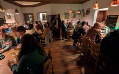
Welcome to our new EAGLEs – Embarking on an Earth Observation Journey
As the autumn term begins and the leaves turn golden across Europe, we are pleased to welcome a fresh cohort of EAGLEs—our new MSc students in Earth Observation and Geoinformatics. This year’s group brings together curious minds from diverse academic and cultural...
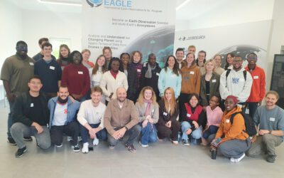
New EAGLEs take off into the Winter Term 2025/26
As in previous years, the next generation of EAGLE Master's students from around the world gathered at the Earth Observation Research Center (EORC) on the first day of the winter term to begin their studies at the University of Würzburg. Prof. Dr. Tobias Ullmann...
EAGLE MSc Defense “Coastal Urban Flood Detection and Analysis Using SAR and CNN-Based Methods: A Case Study for Central Vietnam”
On September 23, 2025, Elly Schmid will present her Master Thesis on " Urban Flood Detection and Analysis Using SAR and CNN-Based Methods: A Case Study for Central Vietnam" at 12:00 in seminar room 3, John-Skilton-Str. 4a. From the abstract: With over half of the...
EAGLE MSc Defense “Utilizing deep learning and Earth Observation data to predict land cover changes in Volcanoes National Park, Rwanda”
On September 16, 2025, Jean de Dieu Tuyizere will present his Master Thesis on "Utilizing deep learning and Earth Observation data to predict land cover changes in Volcanoes National Park, Rwanda" at 12:00 in seminar room 3, John-Skilton-Str. 4a From the abstract:...
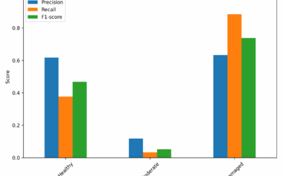
Mapping Fire from the Sky – Anna Bischof’s MSc Thesis on Savanna Fire Patterns
Wildfires are an essential ecological process in African savannas, shaping landscapes, influencing biodiversity, and playing a key role in nutrient cycling. Understanding their dynamics is crucial for both science and management – and this is where EAGLE MSc student...
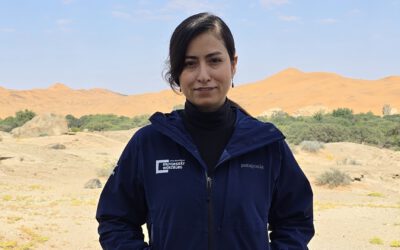
Exploring the Desert: Farimah’s Internship at Gobabeb in Namibia
We’re excited to share that our EAGLE MSc student, Farimah, is currently spending her internship at the renowned Gobabeb Namib Research Institute, nestled in the heart of the Namib Desert—one of the oldest and most unique desert ecosystems in the world. Farimah’s...