Aim
Programming and geostatistics for environmental data analysis will be introduced. Advantages of coding approaches are discussed, theory of coding and statistics covered and practical examples provided.
Content
Theoretical basics and practical examples of programming and geostatistics focused on application within remote sensing and GIS are covered. Basic functionality such as script structure, implementation, functions, loops as well as programming syntax using the R language are introduced. Moreover, statistical basics related to environmental analysis are covered ranging from spatial queries to spatial models, e.g. classification and regression.
Coding
Software
Techniques
Content
General Course News and Updates

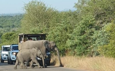
EAGLE Students in Kruger National Park: Internship at SANParks
EAGLE MSc students Sebastian Rothaug and Clemens Schömig are currently completing an internship/InnoLab with SANParks in Kruger National Park, South Africa. During their stay, they are contributing to a project on fire and drought dynamics in savanna ecosystems. Their...
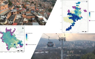
EAGLE MSc Defense: Assessing the accessibility improvements, public perception and potential beneficiaries of cable car systems in Mexico City and Medellin
On March 26, 2026 Angie Torres Lopez will present her Master Thesis on " Assessing the accessibility improvements, public perception and potential beneficiaries of cable car systems in Mexico City and Medellin" at 14:00 in seminar room 3, John-Skilton-Str. 4a. From...
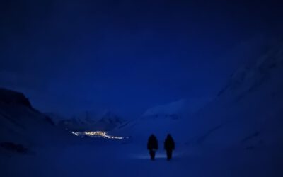
EAGLE M.Sc. Students doing Arctic Internship
This spring, Marlene and Aoibhin, two students from our EAGLE M.Sc. program have started their research internship in the high Arctic on Svalbard. Hosted by Prof. Larissa Beumer at the University Centre in Svalbard (UNIS), the students are gaining hands-on experience...
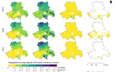
EAGLE MSc Defense: High-Resolution Seasonal Rangeland Carrying Capacity in Central Asia Using Sentinel-2 and the CASA Model
On March 19, 2026, Luis David Almeida Famada will present his Master Thesis on " High-Resolution Seasonal Rangeland Carrying Capacity in Central Asia Using Sentinel-2 and the CASA Model" at 15:00 in seminar room 3, John-Skilton-Str. 4a.High-Resolution Seasonal...
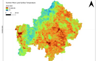
EAGLE MSc Defense: Satellite-Based Assessment of Geo-Climatic Variability in Lower Franconia: Identifying Climate-Related Risks
On March 18, 2026, Jyoti Biswas will present her Master Thesis on " Satellite-Based Assessment of Geo-Climatic Variability in Lower Franconia: Identifying Climate-Related Risks" at 13:00 in seminar room 3, John-Skilton-Str. 4a. From the abstract: The study examines...
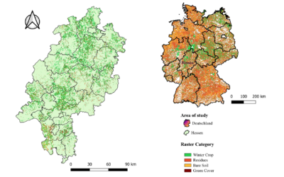
EAGLE Internship Presentation “Validation of High-Resolution Crop Classification Maps in Hessen Using IACS Parcel Data”
On March 24, 2026, Guisseppe Vasquez will present his internship results on " Validation of High-Resolution Crop Classification Maps in Hessen Using IACS Parcel Data " at 12:30 in seminar room 3, John-Skilton-Str. 4a.type of presentation: From the abstract: My...
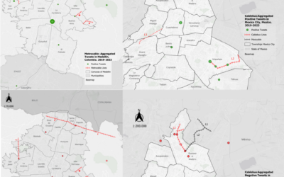
EAGLE Innolab Presentation: People’s Perception of Cable Car Transportation Using Twitter Data
On March 24 2026, Angie Torres will present her Innolab results on " People's Perception of Cable Car Transportation Using Twitter Data" at 12:00 in seminar room 3, John-Skilton-Str. 4a. From the abstract: Urban mobility is commonly analysed through geospatial methods...
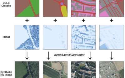
EAGLE MSc Defense: Synthetic High-Resolution Remote Sensing Image Generation – A Comparative Study of Model Training, Surface Data Variability and Evaluation Metrics
On March 26, 2026, Georg Starz will present his Master Thesis on " Synthetic High-Resolution Remote Sensing Image Generation – A Comparative Study of Model Training, Surface Data Variability and Evaluation Metrics" at 10:00 in seminar room 3, John-Skilton-Str. 4a....
EAGLE Student Supports Savanna Monitoring in Kruger National Park
Our EAGLE M.Sc. student Lukas Fronzeck joined Luisa Pflumm, a former EAGLE and now PhD researcher at our Earth Observation Research Cluster (EORC), during fieldwork in Kruger National Park in South Africa. The field campaign forms part of Luisa’s PhD project...
![FW: [EORC Talk] Pathways towards a Healthy City – 10 March 2026, 03 pm](https://eagle-science.org/wp-content/uploads/2026/03/image001.jpg)
FW: [EORC Talk] Pathways towards a Healthy City – 10 March 2026, 03 pm
Dear colleagues and EAGLE students, This is a quick reminder to attend today’s and tomorrow’s EORC Talks, both at 3 p.m. sharp. TODAY 📍 What: EORC Talk on “Pathways towards a Healthy City” (Blog) 📍 Who: Christian Werthmann and Christian Corral...